
Haz una donación
Mapa topográfico Cabauw
Haga clic en el mapa para ver la altitud.
Haz una donación
Acerca de este mapa
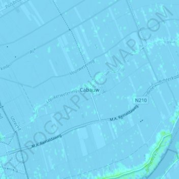
Nombre: Mapa topográfico Cabauw, altitud, relieve.
Lugar: Cabauw, Lopik, Utrecht, Netherlands, 3411 ED, Netherlands (51.94426 4.87778 51.98426 4.91778)
Altitud media: -1 m
Altitud mínima: -5 m
Altitud máxima: 5 m
Haz una donación
Otros mapas topográficos
Haga clic en un mapa para ver su topografía, su altitud y su relieve.
Haz una donación
Haz una donación
Amersfoort
The construction of the tower and the church was started in 1444. The church was destroyed by an explosion in 1787, but the tower survived, and the layout of the church still can be discerned today through the use of different types of stone in the pavement of the open space that was created. It is now the…
Altitud media: 7 m
Haz una donación
De Bilt
Dutch Topographic map of the municipality of De Bilt, June 2015
Altitud media: 4 m
Amersfoort
The construction of the tower and the church was started in 1444. The church was destroyed by an explosion in 1787, but the tower survived, and the layout of the church still can be discerned today through the use of different types of stone in the pavement of the open space that was created. It is now the…
Altitud media: 7 m
Haz una donación
Woudenberg
Netherlands > Utrecht > Woudenberg
Dutch Topographic map of the municipality of Woudenberg, 2013.
Altitud media: 13 m
Haz una donación
Wijk bij Duurstede
Dutch Topographic map of the municipality of Wijk bij Duurstede, 2013.
Altitud media: 7 m
Haz una donación
Wijk bij Duurstede
Netherlands > Utrecht > Wijk bij Duurstede
Dutch Topographic map of the municipality of Wijk bij Duurstede, 2013.
Altitud media: 5 m
Haz una donación
Haz una donación
Amersfoort
The construction of the tower and the church was started in 1444. The church was destroyed by an explosion in 1787, but the tower survived, and the layout of the church still can be discerned today through the use of different types of stone in the pavement of the open space that was created. It is now the…
Altitud media: 7 m
Haz una donación
Rhenen
Rhenen (Dutch pronunciation: [ˈreːnə(n)] ) is a municipality and a city in the central Netherlands. The municipality also includes the villages of Achterberg, Remmerden [nl], Elst and . The town lies at a geographically interesting location, namely on the southernmost part of the chain of hills known as the…
Altitud media: 13 m
Haz una donación
Amersfoort
The construction of the tower and the church was started in 1444. The church was destroyed by an explosion in 1787, but the tower survived, and the layout of the church still can be discerned today through the use of different types of stone in the pavement of the open space that was created. It is now the…
Altitud media: 6 m
Haz una donación
Amersfoort
The construction of the tower and the church was started in 1444. The church was destroyed by an explosion in 1787, but the tower survived, and the layout of the church still can be discerned today through the use of different types of stone in the pavement of the open space that was created. It is now the…
Altitud media: 6 m
Haz una donación
Haz una donación
Haz una donación
Rhenen
Netherlands > Utrecht > Rhenen
Rhenen (Dutch pronunciation: [ˈreːnə(n)] ) is a municipality and a city in the central Netherlands. The municipality also includes the villages of Achterberg, Remmerden, Elst and Laareind. The town lies at a geographically interesting location, namely on the southernmost part of the chain of hills known as…
Altitud media: 14 m
Haz una donación
Montfoort
Netherlands > Utrecht > Montfoort
Dutch topographic map of the municipality of Montfoort, June 2015
Altitud media: 0 m
De Bilt
Dutch Topographic map of the municipality of De Bilt, June 2015
Altitud media: 4 m