
Gracias por apoyar a este sitio ❤️
Haz una donación
Haz una donación
Mapa topográfico Rhenen
Haga clic en el mapa para ver la altitud.
Gracias por apoyar a este sitio ❤️
Haz una donación
Haz una donación
Rhenen
Rhenen (Dutch pronunciation: [ˈreːnə(n)] ) is a municipality and a city in the central Netherlands. The municipality also includes the villages of Achterberg, Remmerden, Elst and Laareind. The town lies at a geographically interesting location, namely on the southernmost part of the chain of hills known as the Utrecht Hill Ridge (Utrechtse Heuvelrug), where this meets the river Rhine. Because of this Rhenen has a unique character with quite some elevation through town.
Gracias por apoyar a este sitio ❤️
Haz una donación
Haz una donación
Acerca de este mapa
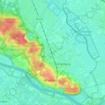
Nombre: Mapa topográfico Rhenen, altitud, relieve.
Lugar: Rhenen, Utrecht, Netherlands (51.94312 5.50789 52.01852 5.62731)
Altitud media: 14 m
Altitud mínima: 1 m
Altitud máxima: 61 m
Gracias por apoyar a este sitio ❤️
Haz una donación
Haz una donación