
Gracias por apoyar a este sitio ❤️
Haz una donación
Haz una donación
Mapa topográfico Hillegom
Haga clic en el mapa para ver la altitud.
Gracias por apoyar a este sitio ❤️
Haz una donación
Haz una donación
Acerca de este mapa
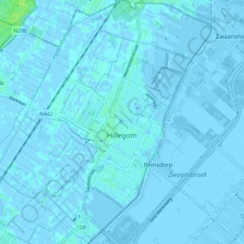
Nombre: Mapa topográfico Hillegom, altitud, relieve.
Lugar: Hillegom, South Holland, Netherlands (52.27124 4.54228 52.31840 4.61170)
Altitud media: -1 m
Altitud mínima: -8 m
Altitud máxima: 11 m
Gracias por apoyar a este sitio ❤️
Haz una donación
Haz una donación
Otros mapas topográficos
Haga clic en un mapa para ver su topografía, su altitud y su relieve.
Gracias por apoyar a este sitio ❤️
Haz una donación
Haz una donación
Gracias por apoyar a este sitio ❤️
Haz una donación
Haz una donación
Gracias por apoyar a este sitio ❤️
Haz una donación
Haz una donación