Geolocalizar

Mapa topográfico Langeraar

Haga clic en el mapa para ver la altitud.

Acerca de este mapa

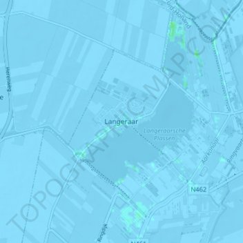
Nombre: Mapa topográfico Langeraar, altitud, relieve.

Lugar: Langeraar, Ter Aar, Nieuwkoop, South Holland, Netherlands, 2461 RW, Netherlands (52.17318 4.68973 52.21318 4.72973)

Altitud media: -3 m

Altitud mínima: -7 m

Altitud máxima: 4 m

Otros mapas topográficos

Haga clic en un mapa para ver su topografía, su altitud y su relieve.

Rotterdam

Netherlands > South Holland

Altitud media: 0 m

Leiden

Netherlands > South Holland

Altitud media: 1 m

The Hague

Netherlands > South Holland

Altitud media: 2 m

Leiden

Netherlands > South Holland

Altitud media: 1 m

Delft

Netherlands > South Holland > Delft

Altitud media: 0 m

Leiden

Netherlands > South Holland

Altitud media: 1 m

The Hague

Netherlands > South Holland

Altitud media: 2 m

Rotterdam

Netherlands > South Holland

Altitud media: 0 m

The Hague

Netherlands > South Holland

Altitud media: 2 m

Waddinxveen

Netherlands > South Holland

Altitud media: -3 m

Delft

Netherlands > South Holland > Delft

Altitud media: 0 m

Delft

Netherlands > South Holland

Altitud media: 0 m

Kinderdijk

Netherlands > South Holland

Altitud media: 1 m

Dordrecht

Netherlands > South Holland

Altitud media: 1 m

Monster

Netherlands > South Holland

Altitud media: 1 m

Numansdorp

Netherlands > South Holland

Altitud media: 0 m

Schiedam

Netherlands > South Holland

Altitud media: 1 m

Leiden

Netherlands > South Holland

Altitud media: 1 m

Wassenaar

Netherlands > South Holland

Altitud media: 3 m

Hendrik-Ido-Ambacht

Netherlands > South Holland > Hendrik-Ido-Ambacht

Dutch topographic map of the municipality of Hendrik-Ido-Ambacht, June 2015

Altitud media: 1 m

Meije

Netherlands > South Holland > Nieuwkoop

Altitud media: -2 m

Dordrecht

Netherlands > South Holland

Altitud media: 1 m

Noordwijkerhout

Netherlands > South Holland > Noordwijk

Dutch topographic map of the municipality of Noordwijkerhout, June 2015

Altitud media: 2 m

Sliedrecht

Netherlands > South Holland

Dutch topographic map of the municipality of Sliedrecht, June 2015

Altitud media: 0 m

Ouddorp

Netherlands > South Holland

Altitud media: 0 m

Nootdorp

Netherlands > South Holland

Altitud media: -2 m

Oostvoorne

Netherlands > South Holland

Altitud media: 2 m

The Hague

Netherlands > South Holland

Altitud media: 2 m

The Hague

Netherlands > South Holland

Altitud media: 2 m

Noordeloos

Netherlands > South Holland

Altitud media: -1 m

Rotterdam

Netherlands > South Holland

Altitud media: 0 m

Gorinchem

Netherlands > South Holland

Altitud media: 1 m

Rotterdam

Netherlands > South Holland

Altitud media: 0 m

The Hague

Netherlands > South Holland

Altitud media: 2 m

The Hague

Netherlands > South Holland

Altitud media: 2 m

Pernis

Netherlands > South Holland

Altitud media: 3 m

Pernis

Netherlands > South Holland

Altitud media: 3 m

Rotterdam

Netherlands > South Holland

Altitud media: 0 m

Ankerpark

Netherlands > South Holland > Leiden

Altitud media: 3 m

Katwijk

Netherlands > South Holland

Altitud media: 3 m

Noordwijkerhout

Netherlands > South Holland > Noordwijk

Dutch topographic map of the municipality of Noordwijkerhout, June 2015

Altitud media: 2 m

Delft

Netherlands > South Holland > Delft

Altitud media: 0 m

Streefkerk

Netherlands > South Holland

Altitud media: -1 m

Rotterdam

Netherlands > South Holland

Altitud media: 0 m

Botlek

Netherlands > South Holland

Altitud media: 3 m

Bleiswijk

Netherlands > South Holland

Altitud media: -4 m

Naaldwijk

Netherlands > South Holland

Altitud media: 1 m

Delft

Netherlands > South Holland > Delft

Altitud media: 0 m

Sliedrecht

Netherlands > South Holland

Dutch topographic map of the municipality of Sliedrecht, June 2015

Altitud media: 0 m

Berkenwoude

Netherlands > South Holland

Altitud media: -1 m

Delfgauw

Netherlands > South Holland

Altitud media: -1 m

Capelle aan den IJssel

Netherlands > South Holland

Dutch Topographic map of the municipality of Capelle aan den IJssel, June 2015.

Altitud media: -1 m

Piershil

Netherlands > South Holland

Altitud media: 0 m

Noordwijk

Netherlands > South Holland

Altitud media: 1 m

Rijswijk

Netherlands > South Holland

Altitud media: 2 m

Berkenwoude

Netherlands > South Holland

Altitud media: -1 m

Zuidplas

Netherlands > South Holland

Dutch Topographic map of the municipality of Zuidplas, September 2014

Altitud media: -3 m

Gouda

Netherlands > South Holland

Altitud media: -1 m

Teylingen

Netherlands > South Holland

Altitud media: 0 m

Monster

Netherlands > South Holland

Altitud media: 1 m

Heenvliet

Netherlands > South Holland

Altitud media: 1 m

Naaldwijk

Netherlands > South Holland

Altitud media: 1 m

Ouddorp

Netherlands > South Holland

Altitud media: 0 m

Delft

Netherlands > South Holland

Altitud media: 0 m

Europoort

Netherlands > South Holland

Altitud media: 2 m

Katwijk

Netherlands > South Holland

Altitud media: 3 m

Hillegom

Netherlands > South Holland

Altitud media: -1 m

Dordrecht

Netherlands > South Holland

Altitud media: 1 m

Gorinchem

Netherlands > South Holland

Altitud media: 1 m

Rotterdam

Netherlands > South Holland

Altitud media: 0 m

Dordrecht

Netherlands > South Holland

Altitud media: 1 m

Lisse

Netherlands > South Holland > Lisse

Altitud media: -1 m

The Hague

Netherlands > South Holland

Altitud media: 2 m

The Hague

Netherlands > South Holland

Altitud media: 2 m