
Haz una donación
Mapa topográfico Lucéram
Haga clic en el mapa para ver la altitud.
Haz una donación
Lucéram
The town is built on a rocky outcrop overlooking the Foil. In the lower valley, there is an intersection of the salt road that leads from the port of Nice in Savoy, through the valley of Vésubie. The village lies at 650 meters altitude, and 27 kilometers from Nice by D 2566.
Haz una donación
Acerca de este mapa
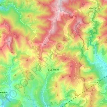
Nombre: Mapa topográfico Lucéram, altitud, relieve.
Altitud media: 895 m
Altitud mínima: 350 m
Altitud máxima: 1.585 m
Haz una donación
Otros mapas topográficos
Haga clic en un mapa para ver su topografía, su altitud y su relieve.
La Redoute des 3 Communes
France > Provence-Alpes-Côte d'Azur > Maritime Alps > Moulinet
Altitud media: 1.739 m
Auron
France > Provence-Alpes-Côte d'Azur > Maritime Alps > Saint-Étienne-de-Tinée
Auron is a ski resort in the department of Alpes-Maritimes and the region of Provence-Alpes-Côte d'Azur in France. The resort has 135 kilometres (84 mi) of ski runs, at an elevation of between 1,600 and 2,450 m (5,250 and 8,040 ft) in the French Alps. It is located above the Tinée Valley near the town of…
Altitud media: 1.654 m
Puget-Théniers
France > Provence-Alpes-Côte d'Azur > Maritime Alps > Puget-Théniers
Altitud media: 688 m
Haz una donación
Gorgia
France > Provence-Alpes-Côte d'Azur > Maritime Alps > Saint-Étienne-de-Tinée
Altitud media: 1.513 m
Haz una donación
Haz una donación
Mont Agel
France > Provence-Alpes-Côte d'Azur > Maritime Alps > Peille
Mont Agel is a mountain in the Maritime Alps on the border between France and Monaco. The summit of this mount, at 1,148 metres (3,766 ft) above sea level, is on the French side, but the highest point of Monaco, lying on a pathway named Chemin des Révoires, is on its slopes, at an altitude of 161 metres (528…
Altitud media: 790 m
La Madone
France > Provence-Alpes-Côte d'Azur > Maritime Alps > Saint-Martin-Vésubie
Altitud media: 1.151 m
Haz una donación
Mont Agel
France > Provence-Alpes-Côte d'Azur > Maritime Alps > Peille
Mont Agel is a mountain on the border between France and Monaco. The summit of this mount, at 1,148 metres (3,766 ft) above sea level, is on the French side, but the highest point of Monaco, lying on a pathway named Chemin des Révoires, is on its slopes, at an altitude of 161 metres (528 feet).
Altitud media: 790 m
Cime de la Bonette
France > Provence-Alpes-Côte d'Azur > Maritime Alps > Saint-Dalmas-le-Selvage
Altitud media: 2.512 m
Haz una donación
Haz una donación
Réca Véssas
France > Provence-Alpes-Côte d'Azur > Maritime Alps > Clans > Bancairon
Altitud media: 625 m
Haz una donación