
Gracias por apoyar a este sitio ❤️
Haz una donación
Haz una donación
Mapa topográfico Auron
Haga clic en el mapa para ver la altitud.
Gracias por apoyar a este sitio ❤️
Haz una donación
Haz una donación
Auron
Auron is a ski resort in the department of Alpes-Maritimes and the region of Provence-Alpes-Côte d'Azur in France. The resort has 135 kilometres (84 mi) of ski runs, at an elevation of between 1,600 and 2,450 m (5,250 and 8,040 ft) in the French Alps. It is located above the Tinée Valley near the town of Saint-Étienne-de-Tinée. It is situated 95 kilometres (59 mi) north of Nice. The resort is part of the Stations du Mercantour group, along with Isola 2000 and St. Dalmas.
Gracias por apoyar a este sitio ❤️
Haz una donación
Haz una donación
Acerca de este mapa
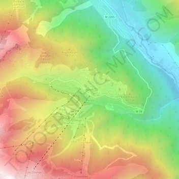
Nombre: Mapa topográfico Auron, altitud, relieve.
Altitud media: 1.654 m
Altitud mínima: 1.055 m
Altitud máxima: 2.376 m
Gracias por apoyar a este sitio ❤️
Haz una donación
Haz una donación