
Mapa topográfico La Muralla
Mapa interactivo
Haga clic en el mapa para ver la altitud.
Acerca de este mapa
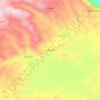
Nombre: Mapa topográfico La Muralla, altitud, relieve.
Altitud media: 1.714 m
Altitud mínima: 1.367 m
Altitud máxima: 1.928 m
Otros mapas topográficos
Haga clic en un mapa para ver su topografía, su altitud y su relieve.
Isnos Huila
Isnos Huila, Isnos, Sur, Huila, RAP (Especial) Central, Colombia
Altitud media: 1.782 m
El Mortiño
El Mortiño, Isnos, Sur, Huila, RAP (Especial) Central, 418060, Colombia
Altitud media: 1.591 m
Parque Nacional Natural Puracé
Parque Nacional Natural Puracé, Isnos, Sur, Huila, RAP (Especial) Central, Colombia
Altitud media: 2.708 m
Paloquemao
Paloquemao, Isnos, Sur, Huila, RAP (Especial) Central, Colombia
Altitud media: 2.152 m