
Haz una donación
Mapa topográfico Isnos Huila
Haga clic en el mapa para ver la altitud.
Haz una donación
Acerca de este mapa
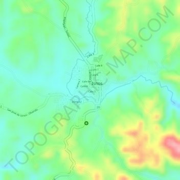
Nombre: Mapa topográfico Isnos Huila, altitud, relieve.
Lugar: Isnos Huila, Sur, Huila, RAP (Especial) Central, Colombia (1.92338 -76.22279 1.93485 -76.21165)
Altitud media: 1.782 m
Altitud mínima: 1.738 m
Altitud máxima: 1.863 m
Haz una donación
Otros mapas topográficos
Haga clic en un mapa para ver su topografía, su altitud y su relieve.
Neiva
Debido a su ubicación cerca de la línea del ecuador y su baja altitud, la ciudad tiene se encuentra en el piso térmico cálido con temperaturas anuales promedio durante el día que van desde 21 hasta 35 grado celsius. La variable temperatura siempre guarda cierta relación con la precipitación, de manera…
Altitud media: 1.032 m
Parque Nacional Natural Puracé
El parque nacional natural Puracé se encuentra en la reserva de biosfera del cinturón andino, región del Macizo Colombiano perteneciente a la cordillera Central de los Andes en Colombia. Su superficie hace parte de los departamentos del Cauca y del Huila. Su altitud es de 4646 msnm; en el parque se…
Altitud media: 2.708 m
Acevedo
La economía seguía siendo campesina y de autoconsumo, basada en maíz, yuca, plátano y caña, pero lentamente se incorporaba el café como cultivo alternativo en las laderas de mayor altitud. Aunque en pequeña escala, el café comenzó a generar excedentes para el mercado regional, preparando el camino…
Altitud media: 1.375 m
Haz una donación
Garzón
Garzón limita por el norte con el municipio de Gigante, por el sur con el municipio de Guadalupe, al suroeste con los municipios de Altamira; por el oriente con el departamento del Caquetá y por el occidente con el municipio de Agrado. Debido a su topografía, se encuentra subdividida en distintas regiones.
Altitud media: 1.366 m
Haz una donación
Saladoblanco
Saladoblanco es un municipio colombiano localizado al suroeste del departamento del Huila. Yace sobre las ramificaciones de la cordillera central y el flanco oriental, que se define topográficamente en algunas mesetas y colinas; también en parte de las estribaciones de la serranía de las Minas. Hace parte…
Altitud media: 1.851 m
Haz una donación
Palestina
Al suroeste del departamento del Huila se encuentra el municipio de Palestina. La mayor parte de su territorio es montañoso, pero también presenta unas zonas planas principalmente en los valles del río Guarapas. La formación orográfica más destacada es la serranía de la Ceja que se desprende de los…
Altitud media: 1.945 m
Palermo
Topográficamente en el territorio se distinguen cuatro regiones diferentes que van de sur a norte : Al occidente una zona montañosa correspondiente a la vertiente oriental de la cordillera central, luego un pintoresco valle en donde está la cabecera municipal, a continuación un cordón de cerros…
Altitud media: 975 m
Guadalupe
Guadalupe es un municipio colombiano ubicado al sur del departamento de Huila, a margen izquierda del valle del río Suaza, sobre los flancos de la cordillera Oriental. Su extensión territorial es de 242 km², se encuentra a una altitud de 940 m s. n. m. y su temperatura promedio es de 22 °C.
Altitud media: 1.334 m
Haz una donación
Campoalegre
Estas manzanas aprovecharon la topografía relativamente plana y con leve pendiente este a oeste, limitada al sur por la quebrada La Caraguaja, y al norte por el Río Frío, dividido por el arroyo del Lavapatas. El núcleo se constituyó en el elemento generador de las principales actividades humanas, con sus…
Altitud media: 1.063 m
Aipe
Aipe es un municipio colombiano ubicado en el noroccidente del departamento de Huila. Tiene una extensión territorial de 801.04 km², que corresponde al 3.8% del área total del departamento. Está ubicado a una altitud de 350 metros sobre el nivel de mar, con temperatura promedio anual de 28.4°C. El casco…
Altitud media: 651 m
Suaza
El municipio de Suaza está situado sobre el costado occidental de la cordillera Oriental de los Andes colombianos y al suroriente del Departamento de Huila, en la región central del valle que forma el río Suaza y los Andes. Tiene una superficie total de 336 km². Al occidente el municipio colinda con la…
Altitud media: 1.549 m
Haz una donación
Haz una donación
Haz una donación
Haz una donación
Haz una donación
Santa María
Como vemos, se refiere a la cordillera central, concretamente a la región comprendida entre La Plata y Órganos, este último sitio ubicado al Noreste de Santa María en territorio del Municipio de Neiva. La presencia en la mayoría de las lomas y faldas que conforman la topografía samaria, de pequeñas…
Altitud media: 1.864 m
Haz una donación
Nátaga
El clima junto con los suelos se convierten en el factor determinante de la productividad de un territorio. Desde luego el clima lo determinan la altitud, las lluvias, los vientos y otros factores. El Municipio de Nátaga en su fisiografía presenta el aspecto de un plano inclinado cuya pendiente topográfica…
Altitud media: 1.513 m
Haz una donación
Tello
Colombia > Huila > Tello > Tello
Tello es un municipio colombiano ubicado en el departamento de Huila. Se caracteriza por su extensa llanura comprendida entre el río Magdalena y el pie de la cordillera oriental hasta sus cimas, con más de 3000 msnm, regados por las aguas de los ríos Fortalecillas y Villavieja. Su extensión territorial es…
Altitud media: 604 m
Haz una donación
Haz una donación
Haz una donación
Haz una donación
Haz una donación
Haz una donación
Haz una donación
Haz una donación
Haz una donación
Aipe
Colombia > Huila > Aipe > Aipe
Aipe es un municipio colombiano ubicado en el noroccidente del departamento de Huila. Tiene una extensión territorial de 801.04 km², que corresponde al 3.8% del área total del departamento. Está ubicado a una altitud de 350 metros sobre el nivel de mar, con temperatura promedio anual de 28.4°C. El casco…
Altitud media: 398 m
Haz una donación
Perímetro Urbano Neiva
Debido a su ubicación cerca de la línea del ecuador y su baja altitud, la ciudad tiene se encuentra en el piso térmico cálido con temperaturas anuales promedio durante el día que van desde 21 hasta 35 grado celsius. La variable temperatura siempre guarda cierta relación con la precipitación, de manera…
Altitud media: 469 m
Haz una donación
Haz una donación
Haz una donación
Haz una donación