
Haz una donación
Mapa topográfico The Bottom
Haga clic en el mapa para ver la altitud.
Haz una donación
Acerca de este mapa
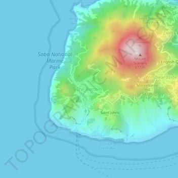
Nombre: Mapa topográfico The Bottom, altitud, relieve.
Lugar: The Bottom, Saba, Netherlands (17.60635 -63.26900 17.64635 -63.22900)
Altitud media: 156 m
Altitud mínima: 0 m
Altitud máxima: 847 m
Haz una donación
Otros mapas topográficos
Haga clic en un mapa para ver su topografía, su altitud y su relieve.
Amsterdam
Amsterdam is located in the Western Netherlands, in the province of North Holland, the capital of which is not Amsterdam, but rather Haarlem. The river Amstel ends in the city centre and connects to a large number of canals that eventually terminate in the IJ. Amsterdam's elevation is about −2 m (−6.6 ft)…
Altitud media: 0 m
Bonaire
While Bonaire has some hills and variations in altitude, Klein Bonaire's surface is quite level and just about two meters above sea level. Because Klein Bonaire is as yet undeveloped, the fringing reef system surrounding Klein Bonaire is pristine.
Altitud media: 1 m
Haz una donación
Haz una donación
Haz una donación
Haz una donación
Eindhoven
The villages and city that make up modern Eindhoven were originally built on sandy elevations between the Dommel, Gender and Tongelreep rivers. Beginning in the 19th century, the basins of the rivers themselves have also been used as housing land, resulting in occasional flooding in the city centre. Partly to…
Altitud media: 20 m
Bonaire
While Bonaire has some hills and variations in altitude, Klein Bonaire's surface is quite level and just about two meters above sea level. Because Klein Bonaire is as yet undeveloped, the fringing reef system surrounding Klein Bonaire is pristine.
Altitud media: 1 m
Haz una donación
Haz una donación
Bonaire
Klein Bonaire, the small island in the sheltered lee of Bonaire, has the same geological history. While Bonaire has some hills and variations in altitude, Klein Bonaire's surface is quite level and just a few feet above high tide. Because the island is as yet undeveloped, the fringing reef system surrounding…
Altitud media: 6 m
Haz una donación
Haz una donación
Haz una donación
Apeldoorn
In 1689 William III became King of England, Scotland and Ireland and this elevation of his position and power brought an enlargement of Het Loo in its wake. Between 1691 and 1694 the colonnades which linked the corps de logis to the wings on either side were replaced by four pavilions. These pavilions…
Altitud media: 26 m
Saba
There is an 8.6 hectares (21 acres) cloud forest located at and above 825 metres (2,707 ft) on top of the mountain referred to as the "Elfin Forest Reserve" because of its high altitude mist and mossy appearance. The most dominant tree in the cloud forest is the Mountain Mahogany (Freziera undulate), although…
Altitud media: 2 m
Haz una donación
Bonaire
Klein Bonaire, the small island in the sheltered lee of Bonaire, has the same geological history. While Bonaire has some hills and variations in altitude, Klein Bonaire's surface is quite level and just a few feet above high tide. Because the island is as yet undeveloped, the fringing reef system surrounding…
Altitud media: 1 m
Apeldoorn
In 1689 William III became King of England, Scotland and Ireland and this elevation of his position and power brought an enlargement of Het Loo in its wake. Between 1691 and 1694 the colonnades which linked the corps de logis to the wings on either side were replaced by four pavilions. These pavilions…
Altitud media: 36 m
Haz una donación
Haz una donación
Wageningen
Netherlands > Gelderland > Wageningen
Topographic map of the municipality of Wageningen, July 2013 (click to enlarge)
Altitud media: 14 m
Eindhoven
The villages and city that make up modern Eindhoven were originally built on sandy elevations between the Dommel, Gender and Tongelreep rivers. Beginning in the 19th century, the basins of the rivers themselves have also been used as housing land, resulting in occasional flooding in the city centre. Partly to…
Altitud media: 20 m
Haz una donación
Haz una donación
Breda
Topographic map image of the city of Breda, March 2014. Click to enlarge.
Altitud media: 7 m
Haz una donación
Haz una donación
Haz una donación
Amersfoort
The construction of the tower and the church was started in 1444. The church was destroyed by an explosion in 1787, but the tower survived, and the layout of the church still can be discerned today through the use of different types of stone in the pavement of the open space that was created. It is now the…
Altitud media: 7 m
Haz una donación
North Brabant
The historical region of Kempen occupies the southern part of the province of Noord-Brabant and extends south of Eindhoven far into northern Belgium. To the east it reaches as far as the Meuse valley. The surface topography of De Kempen is very uniform. Most of it lies between 5m/15 ft and 35m/115 ft above sea…
Altitud media: 22 m
Haz una donación
Heerlen
Heerlen's high elevation makes it one of the highest cities above sea level in the Netherlands.
Altitud media: 131 m
Haz una donación
Den Helder
Dutch Topographic map of Den Helder (town), March 2014.
Altitud media: 0 m
Delfzijl
Delfzijl sits at an elevation above low tide, and usually above high tide except for a few days per year. The town is protected by dikes and gates that can be opened to let water out at low tide, and closed to prevent flooding at high tide. When normal draining at low tide is not sufficient water is pumped…
Altitud media: 0 m
Walcheren
Topographic map of Walcheren, 2015-2016. Click to enlarge.
Altitud media: 0 m
Haz una donación
Haz una donación
Haz una donación
Tilburg
In the 1980s, many locations, formerly occupied by wool factories had been filled with small-scale housing projects. This mostly happened when Henk Letschert was mayor of Tilburg. The Heuvel, one of the important squares, had its own lime tree until 27 April 1994, being chopped down for a bicycle parking…
Altitud media: 11 m
Haz una donación
Haz una donación