
Haz una donación
Mapa topográfico Pecan Park
Haga clic en el mapa para ver la altitud.
Haz una donación
Acerca de este mapa
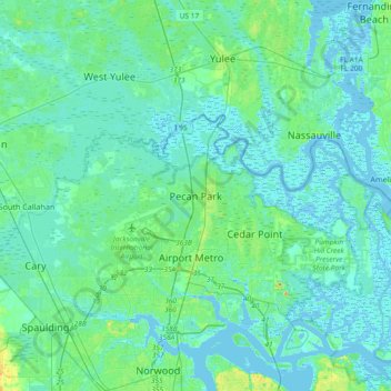
Nombre: Mapa topográfico Pecan Park, altitud, relieve.
Altitud media: 5 m
Altitud mínima: -3 m
Altitud máxima: 31 m
Haz una donación
Otros mapas topográficos
Haga clic en un mapa para ver su topografía, su altitud y su relieve.
Jacksonville
United States > Florida > Duval County
Just south of Jacksonville and north of Saint Augustine is the boundary of where the Floridian Peninsula ends and Continental North America begins; Jacksonville is north of that line. While still in the North American Coastal plain, the topography begins to take on slight Piedmont characteristics. Like the…
Altitud media: 10 m
Jacksonville
United States > Florida > Duval County
Jacksonville features a predominantly flat topography with an average elevation of approximately 16 feet (5 meters) above sea level. This coastal city is characterized by its extensive riverine systems, particularly the St. Johns River, which meanders through the landscape, contributing to a rich ecosystem of…
Altitud media: 10 m
The Lil' Saint John's River
United States > Florida > Duval County > Jacksonville Beach
Altitud media: 3 m
Haz una donación
L C Ringhaver Park
United States > Florida > Duval County > Jacksonville > Venetia Terrace
Altitud media: 5 m
Haz una donación
The Lil' Saint John's River
United States > Florida > Duval County > Jacksonville Beach
Altitud media: 3 m
Haz una donación
Dutton Island Preserve
United States > Florida > Duval County > Jacksonville > Oak Harbor
Altitud media: 2 m
Haz una donación
Haz una donación
Jacksonville
United States > Florida > Duval County
Just south of Jacksonville and north of Saint Augustine is the boundary of where the Floridian Peninsula ends and Continental North America begins; Jacksonville is north of that line. While still in the North American Coastal plain, the topography begins to take on slight Piedmont characteristics. Like the…
Altitud media: 10 m
Haz una donación