
Haz una donación
Mapa topográfico Atlantic Beach
Haga clic en el mapa para ver la altitud.
Haz una donación
Acerca de este mapa
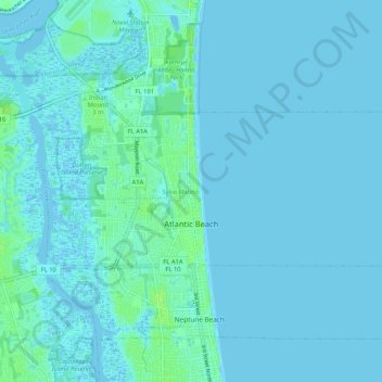
Nombre: Mapa topográfico Atlantic Beach, altitud, relieve.
Lugar: Atlantic Beach, Duval County, Florida, 32233, United States (30.32343 -81.43873 30.36103 -81.33418)
Altitud media: 2 m
Altitud mínima: -4 m
Altitud máxima: 10 m
Haz una donación
Otros mapas topográficos
Haga clic en un mapa para ver su topografía, su altitud y su relieve.
The Lil' Saint John's River
United States > Florida > Duval County > Jacksonville Beach
Altitud media: 3 m
Saint Nicholas
United States > Florida > Duval County > Jacksonville > South Jacksonville
Altitud media: 6 m
Haz una donación
Haz una donación
Haz una donación
L C Ringhaver Park
United States > Florida > Duval County > Jacksonville > Venetia Terrace
Altitud media: 5 m
Haz una donación
Haz una donación
Jacksonville
United States > Florida > Duval County > Jacksonville
Just south of Jacksonville and north of Saint Augustine is the boundary of where the Floridian Peninsula ends and Continental North America begins; Jacksonville is north of that line. While still in the North American Coastal plain, the topography begins to take on slight Piedmont characteristics. Like the…
Altitud media: 9 m
Haz una donación
The Lil' Saint John's River
United States > Florida > Duval County > Jacksonville Beach
Altitud media: 3 m
Haz una donación
Haz una donación
Haz una donación
Haz una donación
Haz una donación
Haz una donación
Haz una donación
Haz una donación
Haz una donación
Haz una donación
Haz una donación
Haz una donación
Haz una donación