
Haz una donación
Mapa topográfico Lubbock
Haga clic en el mapa para ver la altitud.
Haz una donación
Lubbock
Summers are hot, with 78 afternoons on average of 90 °F (32.2 °C)+ highs and 7.4 afternoons of 100 °F (37.8 °C)+ highs, although due to the aridity and elevation, temperatures remain above 70 °F (21.1 °C) on only a few mornings. Lubbock is the 10th-windiest city in the US with an average wind speed of 12.4 mph (20.0 km/h; 5.5 m/s). The highest recorded temperature was 114 °F (45.6 °C) on June 27, 1994.
Haz una donación
Acerca de este mapa
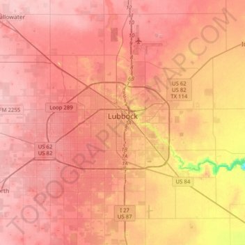
Nombre: Mapa topográfico Lubbock, altitud, relieve.
Lugar: Lubbock, Lubbock County, Texas, United States (33.44786 -102.03212 33.70843 -101.74901)
Altitud media: 983 m
Altitud mínima: 902 m
Altitud máxima: 1.015 m
Haz una donación
Otros mapas topográficos
Haga clic en un mapa para ver su topografía, su altitud y su relieve.
Roosevelt
United States > Texas > Lubbock County
Roosevelt is an unincorporated community in Lubbock County, Texas, United States. It sits at an elevation of 3136 feet (956 m). The community is part of the Lubbock Metropolitan Statistical Area. It mainly consists of Roosevelt High school. There is also a Baptist church here.
Altitud media: 957 m
Haz una donación