
Gracias por apoyar a este sitio ❤️
Haz una donación
Haz una donación
Mapa topográfico Burmarsh
Haga clic en el mapa para ver la altitud.
Gracias por apoyar a este sitio ❤️
Haz una donación
Haz una donación
Acerca de este mapa
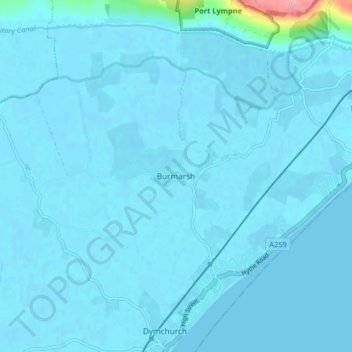
Nombre: Mapa topográfico Burmarsh, altitud, relieve.
Altitud media: 5 m
Altitud mínima: -2 m
Altitud máxima: 113 m
Gracias por apoyar a este sitio ❤️
Haz una donación
Haz una donación
Otros mapas topográficos
Haga clic en un mapa para ver su topografía, su altitud y su relieve.
Greatstone on Sea
United Kingdom > England > Kent > Folkestone and Hythe District > New Romney
Altitud media: 2 m
Gracias por apoyar a este sitio ❤️
Haz una donación
Haz una donación
Park Gate
United Kingdom > England > Kent > Folkestone and Hythe District > Elham
Altitud media: 130 m
Greatstone beach
United Kingdom > England > Kent > Folkestone and Hythe District > New Romney > Littlestone on Sea
Altitud media: 2 m
The Warren
United Kingdom > England > Kent > Folkestone and Hythe District > Folkestone
Altitud media: 46 m
Gracias por apoyar a este sitio ❤️
Haz una donación
Haz una donación
Sandling
United Kingdom > England > Kent > Folkestone and Hythe District > Saltwood
Altitud media: 77 m