
Mapa topográfico Eyjafjallajökull
Mapa interactivo
Haga clic en el mapa para ver la altitud.
Acerca de este mapa
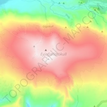
Nombre: Mapa topográfico Eyjafjallajökull, altitud, relieve.
Altitud media: 821 m
Altitud mínima: 109 m
Altitud máxima: 1.628 m
Eyjafjallajökull (Icelandic: (listen); lit. 'glacier of the mountains of the islands') is one of the smaller ice caps of Iceland, north of Skógar and west of Mýrdalsjökull. The ice cap covers the caldera of a volcano with a summit elevation of 1,651 metres (5,417 ft). The volcano has erupted relatively frequently since the Last Glacial Period, most recently in 2010, when, although relatively small for a volcanic eruption, it caused enormous disruption to air travel across western and northern Europe for a week.
Otros mapas topográficos
Haga clic en un mapa para ver su topografía, su altitud y su relieve.
Eyjafjallajökull
Eyjafjallajökull, Rangárþing eystra, Southern Region, Iceland
Altitud media: 1.459 m
Skogafoss
Skogafoss, Rangárþing eystra, Southern Region, Iceland
Altitud media: 145 m