
Haz una donación
Mapa topográfico Somerset
Haga clic en el mapa para ver la altitud.
Haz una donación
Acerca de este mapa
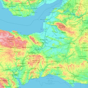
Nombre: Mapa topográfico Somerset, altitud, relieve.
Lugar: Somerset, South West England, England, United Kingdom (50.82084 -3.83980 51.33300 -2.24440)
Altitud media: 87 m
Altitud mínima: -1 m
Altitud máxima: 504 m
Haz una donación
Otros mapas topográficos
Haga clic en un mapa para ver su topografía, su altitud y su relieve.
Cambridge
United Kingdom > England > Cambridge
The city, like most of the UK, has a maritime climate highly influenced by the Gulf Stream. Located in the driest region of Britain, Cambridge's rainfall averages around 570 mm (22.44 in) per year, around half the national average, with some years occasionally falling into the semi-arid (under 500 mm (19.69…
Altitud media: 18 m
City of London
United Kingdom > England > City of London > City of London
The elevation of the City ranges from sea level at the Thames to 21.6 metres (71 ft) at the junction of High Holborn and Chancery Lane. Two small but notable hills are within the historic core, Ludgate Hill to the west and Cornhill to the east. Between them ran the Walbrook, one of the many "lost" rivers or…
Altitud media: 42 m
Haz una donación
Salisbury
United Kingdom > England > Salisbury
Bishop of Salisbury Hubert Walter was instrumental in the negotiations with Saladin during the Third Crusade, but he spent little time in his diocese prior to his elevation to archbishop of Canterbury. The brothers Herbert and Richard Poore succeeded him and began planning the relocation of the cathedral into…
Altitud media: 96 m
Bedford
United Kingdom > England > Bedford
As with the rest of the United Kingdom, Bedford has a maritime climate, with a limited range of temperatures, and generally even rainfall throughout the year. The nearest Met Office weather station to Bedford is Bedford (Thurleigh) airport, about 6.5 miles (10.5 km) north of Bedford town centre at an elevation…
Altitud media: 37 m
Haz una donación
Scarborough
United Kingdom > England > North Yorkshire
The climate is temperate with mild summers and cool, windy, winters. The hottest months of the year are July and August, with temperatures reaching an average high of 17 °C and falling to 11 °C at night. The average daytime temperatures in January are 4 °C, falling to 1 °C at night. The station's elevation…
Altitud media: 39 m
Haz una donación
Peterborough
United Kingdom > England > Cambridgeshire
The local topography is flat, and in some places, the land lies below sea level, for example in parts of the Fens to the east and to the south of Peterborough. Human settlement in the area began before the Bronze Age, as can be seen at the Flag Fen archaeological site to the east of the current city centre,…
Altitud media: 17 m
Leeds
Lying in the eastern foothills of the Pennines, there is a significant variation in elevation within the city's built-up area. The district ranges from 1,115 feet (340 m) in the far west on the slopes of Ilkley Moor to about 33 feet (10 m) where the rivers Aire and Wharfe cross the eastern boundary. Land rises…
Altitud media: 94 m
Haz una donación
Putney
Putney Heath is around 400 acres (160 hectares) less the nascent A3 road in size and rises to 45 metres (148 ft) above sea level. Because of its elevation, from 1796 to 1816 Putney Heath hosted a station in the shutter telegraph chain, which connected the Admiralty in London to its naval ships in Portsmouth.…
Altitud media: 18 m
Haz una donación
Croydon
United Kingdom > England > Greater London
Several apartment developments, for instance Altitude 25 (completed 2010), have been built in recent years, and several more are being built or planned. The construction of Saffron Square, which includes a 43-storey tower, began on Wellesley Road in 2011 and was completed in 2016. Other developments with…
Altitud media: 70 m
Plymouth
United Kingdom > England > Devon > Plymouth
The River Plym, which flows off Dartmoor to the north-east, forms a smaller estuary to the east of the city called Cattewater. Plymouth Sound is protected from the sea by the Plymouth Breakwater, in use since 1814. In the Sound is Drake's Island which is seen from Plymouth Hoe, a flat public area on top of…
Altitud media: 81 m
High Willhays
United Kingdom > England > Devon > West Devon
High Willhays and Yes Tor are the only summits in England south of Kinder Scout in the Peak District to rise above 2,000 feet (610 m), apart from Black Mountain on the Welsh border. Before Ordnance Survey measured accurately the heights of High Willhays and Yes Tor many people believed Yes Tor was the higher…
Altitud media: 512 m
Haz una donación
Hyde Park
United Kingdom > England > London
"It consists of a screen of handsome fluted Ionic columns, with three carriage entrance archways, two-foot entrances, a lodge, etc. The extent of the whole frontage is about 107 ft (33 m). The central entrance has a bold projection: the entablature is supported by four columns; and the volutes of the capitals…
Altitud media: 25 m
Basingstoke
United Kingdom > England > Hampshire > Basingstoke and Deane
Situated in a valley through the Hampshire Downs at an average elevation of 88 metres (289 ft) Basingstoke is a major interchange between Reading, Newbury, Andover, Winchester, and Alton, and lies on the natural trade route between the southwest of England and London. The area had been something of an…
Altitud media: 109 m
Haz una donación
Haz una donación
Haz una donación
Haz una donación
Haz una donación
Littleborough
In the late 18th century, the low-altitude Summit Gap between Littleborough and Walsden was approved as the best route over the Pennines for the Rochdale Canal and the Manchester to Leeds railway; Hollingworth Lake was built at Littleborough's south side as a feeder reservoir to regulate the waters of the…
Altitud media: 266 m
Haz una donación
Haz una donación
Letchworth
United Kingdom > England > Hertfordshire > North Hertfordshire > Letchworth
Altitud media: 80 m
Bishop's Stortford
United Kingdom > England > East Hertfordshire > Bishop's Stortford
Altitud media: 85 m
Haz una donación
Haz una donación
Haz una donación
Haz una donación
Aylesbury
United Kingdom > England > Aylesbury
Aylesbury is immediately southeast of the upper River Thame that flows past Thame to Dorchester on Thames and is partly sited on the two northernmost outcrops of Portland (lime)stone in England bisected by a small stream, Bear Brook which gives a relatively prominent position in relation to the terrain of all…
Altitud media: 84 m
Haz una donación
Haz una donación
Haz una donación
Haz una donación
Atherton
There were several ministers of note of Chowbent Chapel including James Wood, the "General" (1672–1759), who distinguished himself at the Battle of Preston in 1715. Thomas Walker Horsfield (1792–1837) was a historian and topographer. Joseph Nightingale (1775–1824), born in Chowbent, was a prolific…
Altitud media: 69 m
Haz una donación
Tottenham
Tottenham's elevation is approximately 33 ft (10 m) above sea level.
Altitud media: 25 m
Haz una donación
Bebington
Bebington is on the eastern side of the Wirral Peninsula, approximately 10 km (6.2 mi) south-south-east of the Irish Sea at New Brighton, about 7.5 km (4.7 mi) east-north-east of the Dee Estuary at Gayton and less than 2 km (1.2 mi) west-north-west of the River Mersey at New Ferry. The area is situated at an…
Altitud media: 28 m
Haz una donación
Haz una donación