
Haz una donación
Mapa topográfico Manosque
Haga clic en el mapa para ver la altitud.
Haz una donación
Acerca de este mapa
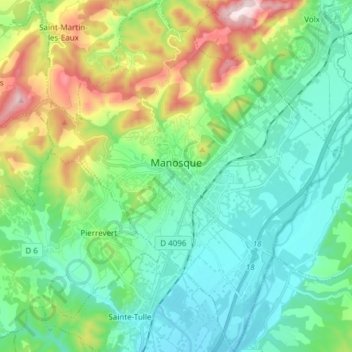
Nombre: Mapa topográfico Manosque, altitud, relieve.
Altitud media: 411 m
Altitud mínima: 274 m
Altitud máxima: 789 m
Haz una donación
Otros mapas topográficos
Haga clic en un mapa para ver su topografía, su altitud y su relieve.
Molanès
France > Provence-Alpes-Côte d'Azur > Alpes-de-Haute-Provence > Uvernet-Fours
Altitud media: 1.566 m
Chavailles
France > Provence-Alpes-Côte d'Azur > Alpes-de-Haute-Provence > Prads-Haute-Bléone
Altitud media: 1.491 m
Le Caravon
France > Provence-Alpes-Côte d'Azur > Alpes-de-Haute-Provence > Oppedette
Altitud media: 553 m
Haz una donación
La Croix
France > Provence-Alpes-Côte d'Azur > Alpes-de-Haute-Provence > Jausiers
Altitud media: 2.128 m
Mont d'Or
France > Provence-Alpes-Côte d'Azur > Alpes-de-Haute-Provence > Manosque
Altitud media: 394 m
Saint-Michel
France > Provence-Alpes-Côte d'Azur > Alpes-de-Haute-Provence > Moustiers-Sainte-Marie
Altitud media: 731 m
La Foux d'Allos
France > Provence-Alpes-Côte d'Azur > Alpes-de-Haute-Provence > Allos
Altitud media: 2.094 m
Haz una donación
Colmars
France > Provence-Alpes-Côte d'Azur > Alpes-de-Haute-Provence > Colmars > Colmars
Altitud media: 1.565 m
Barcelonnette
France > Provence-Alpes-Côte d'Azur > Alpes-de-Haute-Provence > Barcelonnette > Barcelonnette
Barcelonnette is situated in the wide and fertile Ubaye Valley, of which it is the largest town. It lies at an elevation of 1132 m (3717 ft) on the right bank of the Ubaye River, and is surrounded by mountains which reach peaks of over 3000 m; the tallest of these is the Needle of Chambeyron at 3412 m.…
Altitud media: 1.494 m
Aurafrède
France > Provence-Alpes-Côte d'Azur > Alpes-de-Haute-Provence > Gréoux-les-Bains
Altitud media: 389 m
Tournoux
France > Provence-Alpes-Côte d'Azur > Alpes-de-Haute-Provence > Saint-Paul-sur-Ubaye
Altitud media: 1.787 m
Haz una donación
Brame-Faim
France > Provence-Alpes-Côte d'Azur > Alpes-de-Haute-Provence > Mirabeau
Altitud media: 624 m
Pont de la Serre
France > Provence-Alpes-Côte d'Azur > Alpes-de-Haute-Provence > Colmars
Altitud media: 1.990 m
La Colle Saint-Michel
France > Provence-Alpes-Côte d'Azur > Alpes-de-Haute-Provence > Thorame-Haute
Altitud media: 1.370 m