
Gracias por apoyar a este sitio ❤️
Haz una donación
Haz una donación
Mapa topográfico Malinao
Haga clic en el mapa para ver la altitud.
Gracias por apoyar a este sitio ❤️
Haz una donación
Haz una donación
Malinao
Malinao occupies a narrow stretch of plains hemmed in by the Lagonoy Gulf in the east and Mount Malinao on the west. The area is dominated by the mountain ranges of Malinao, with a peak altitude of 1,584 metres (5,197 ft) above sea level.
Gracias por apoyar a este sitio ❤️
Haz una donación
Haz una donación
Acerca de este mapa
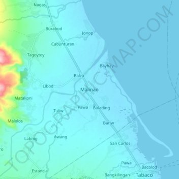
Nombre: Mapa topográfico Malinao, altitud, relieve.
Lugar: Malinao, Albay, Bicol Region, 4514, Philippines (13.35746 123.66498 13.43746 123.74498)
Altitud media: 17 m
Altitud mínima: -1 m
Altitud máxima: 217 m
Gracias por apoyar a este sitio ❤️
Haz una donación
Haz una donación
Otros mapas topográficos
Haga clic en un mapa para ver su topografía, su altitud y su relieve.