
Mapa topográfico Herongen
Mapa interactivo
Haga clic en el mapa para ver la altitud.
Acerca de este mapa
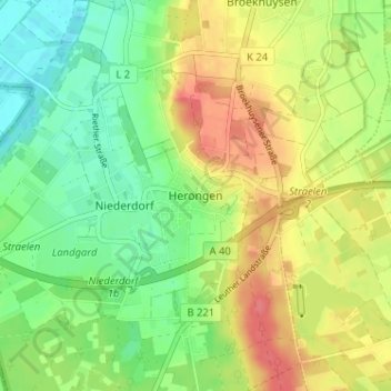
Nombre: Mapa topográfico Herongen, altitud, relieve.
Altitud media: 45 m
Altitud mínima: 18 m
Altitud máxima: 78 m
Otros mapas topográficos
Haga clic en un mapa para ver su topografía, su altitud y su relieve.
Holt
Deutschland > Nordrhein-Westfalen > Kreis Kleve > Straelen > Auwel
Holt, Auwel, Straelen, Kreis Kleve, Nordrhein-Westfalen, 47638, Deutschland
Altitud media: 32 m
Zand
Deutschland > Nordrhein-Westfalen > Kreis Kleve > Straelen
Zand, Straelen, Kreis Kleve, Nordrhein-Westfalen, 47638, Deutschland
Altitud media: 40 m