
Mapa topográfico Serra da Estrela Nature Park
Mapa interactivo
Haga clic en el mapa para ver la altitud.
Acerca de este mapa
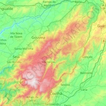
Nombre: Mapa topográfico Serra da Estrela Nature Park, altitud, relieve.
Altitud media: 740 m
Altitud mínima: 198 m
Altitud máxima: 1.989 m
Serra da Estrela Natural Park is situated in the largest mountain range in Portugal - the Serra da Estrela, and is the source of the rivers Mondego, Zêzere (tributary of the Tagus), and Alva. The park is the largest natural conservation area in Portugal and occupies about 1,000 km2. More than half of its area is located above an altitude of 700 m. At 1,993 m it contains the highest peak in Continental Portugal (named Torre) and a ski resort (named Vodafone Ski Resort).
Otros mapas topográficos
Haga clic en un mapa para ver su topografía, su altitud y su relieve.
Vila Franca da Serra
Vila Franca da Serra, Gouveia, Guarda, Portugal
Altitud media: 402 m