
Haz una donación
Mapa topográfico Negros
Haga clic en el mapa para ver la altitud.
Haz una donación
Acerca de este mapa
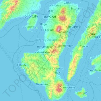
Nombre: Mapa topográfico Negros, altitud, relieve.
Lugar: Negros, Negros Island Region, Philippines (9.03808 122.37590 11.00300 123.56886)
Altitud media: 114 m
Altitud mínima: -2 m
Altitud máxima: 2.362 m
Haz una donación
Otros mapas topográficos
Haga clic en un mapa para ver su topografía, su altitud y su relieve.
Baguio
Philippines > Benguet > Baguio
In 1903, Filipinos, Japanese and Chinese workers were hired to build Kennon Road, the first road directly connecting Baguio with the lowlands of La Union and Pangasinan. Before this, the only road to Benguet was Naguilian Road, and it was largely a horse trail at higher elevations. Camp John Hay was…
Altitud media: 882 m
Tagaytay
Philippines > Cavite > Tagaytay > Tagaytay
The southern and eastern portions of Tagaytay are covered by hills and mountains which is generally forests, pine trees and open grasslands. The city lies along Tagaytay Ridge, a ridge stretching about 32 kilometres (20 mi) from Mount Batulao in the west to Mount Sungay in the east with elevations averaging…
Altitud media: 229 m
Antipolo
Its higher elevation than that of Metro Manila affords it a scenic view of the metropolis, especially at night. Its locally grown mangoes and cashews are popular among tourists, as well as suman – a local delicacy made out of glutinous rice. The Hinulugang Taktak National Park, which was once a popular…
Altitud media: 125 m
Haz una donación
San Jose del Monte
The elevation of the city ranges from approximately 40 to 900 meters (130 to 2,950 ft) above sea level; the relief transitions from warm lowland to cool upland as one goes eastward. This is because the city is part of the Sierra Madre mountain range. Plains and river valley flats characterize the western and…
Altitud media: 106 m
Clark
The development is not a flood-prone area with its minimum elevation being at 54 metres (177 ft) above sea level and its planned central park also serves as a flood catchment basin. The Sierra Madre mountain range is located on the development's east while the Zambales mountain range is located on the west,…
Altitud media: 190 m
Haz una donación
Dumaguete
Philippines > Negros Oriental > Dumaguete
As a coastal city, it is bounded on the east by the Bohol Sea and the Tañon Strait, serving as a natural border of southeastern Negros Island Region to the neighboring Central Visayas. The city's topography is generally flat from two to six kilometers from the shoreline. It slopes gently upwards to the…
Altitud media: 167 m
Haz una donación
Haz una donación
Haz una donación
Haz una donación
Haz una donación
Santa Maria
The topography of Santa Maria is generally flat, however, it is becoming hilly towards the north. This area covers the barangays of Silangan, Mag-asawang Sapa, Pulong Buhangin and some parts of Balasing with landscape ranging from 8 to 18 percent slope. The rest of the barangays have a slope range from level…
Altitud media: 18 m
Haz una donación
Butuan
Philippines > Agusan del Norte > Butuan
Butuan is located at 8°57′N 125°32′E / 8.95°N 125.53°E / 8.95; 125.53. Elevation at these coordinates is estimated at 1.0 meter above sea level (M.a.s.l.).
Altitud media: 115 m
Haz una donación
Haz una donación
Mounts Palay-Palay–Mataas-na-Gulod Protected Landscape
Philippines > Cavite > Ternate
A 38.3 kilometres (23.8 mi) trail traversing the mountains of the protected landscape has been mapped and established by a five-man expedition team in 2014, to which the trail starts at Barangay Ramirez of Magallanes, Cavite passing through Mataas na Gulod, Dos Picos, Kalanggaman, and ends at Mount Palay-Palay…
Altitud media: 206 m
Haz una donación
Haz una donación
Haz una donación
Pandi
Pandi is rich in many natural brooks coming from the mainland itself. In some remote areas the lands are still covered by bamboo trees that naturally thrive and multiplies. Some lands privately owned have mango plantations. In some areas that are privately owned are rock deposits being used for housing…
Altitud media: 27 m
Haz una donación
Bataan
Bataan is divided by two mountain groups of volcanic origins. The northern side is composed of the Mount Natib (elevation 1,253 metres (4,111 ft)), Mount Sta. Rosa and Mount Silangan. The southern group is composed of Mount Mariveles, Mount Samat, and Mount Cuyapo. A narrow pass separates these two mountain…
Altitud media: 92 m
Haz una donación
Haz una donación
Haz una donación
Cabadbaran
Philippines > Agusan del Norte
It is generally flat with rolling hills and swamplands in its western part. The highest of all mountains in the Caraga region, Mount Hilong-Hilong (with an altitude of 2,012 metres (6,601 ft) above sea level), rises in this city.
Altitud media: 179 m
Haz una donación
Haz una donación
Mount Sungay
Philippines > Cavite > Tagaytay > Iruhin South
Mount Sungay is the eastern end of the Tagaytay Range, or more commonly known as the Tagaytay Ridge, a 32-kilometre (20 mi) ridge located at the southern part of the province with elevations averaging about 600 m (2,000 ft) above sea level. The ridge stretches west-southwest from Mount Sungay to Mount Batulao…
Altitud media: 501 m
Haz una donación
Haz una donación
Haz una donación
Haz una donación
Haz una donación
Haz una donación