
Gracias por apoyar a este sitio ❤️
Haz una donación
Haz una donación
Mapa topográfico Taft Heights
Haga clic en el mapa para ver la altitud.
Gracias por apoyar a este sitio ❤️
Haz una donación
Haz una donación
Taft Heights
Taft Heights (formerly, Boust City) is a census-designated place (CDP) in Kern County, California, United States. Taft Heights is located 1 mile (1.6 km) west-southwest of Taft, at an elevation of 1,178 feet (359 m). The population was 1,949 at the 2010 census, up from 1,865 at the 2000 census.
Gracias por apoyar a este sitio ❤️
Haz una donación
Haz una donación
Acerca de este mapa
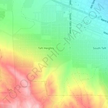
Nombre: Mapa topográfico Taft Heights, altitud, relieve.
Lugar: Taft Heights, Taft, Kern County, California, United States (35.12960 -119.47860 35.13679 -119.46470)
Altitud media: 368 m
Altitud mínima: 274 m
Altitud máxima: 493 m
Gracias por apoyar a este sitio ❤️
Haz una donación
Haz una donación