
Gracias por apoyar a este sitio ❤️
Haz una donación
Haz una donación
Mapa topográfico Deadhorse
Haga clic en el mapa para ver la altitud.
Gracias por apoyar a este sitio ❤️
Haz una donación
Haz una donación
Deadhorse
In February 2023, a "high altitude object" about the size of a small car was shot down near the area after a decision by President Joe Biden.
Gracias por apoyar a este sitio ❤️
Haz una donación
Haz una donación
Acerca de este mapa
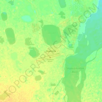
Nombre: Mapa topográfico Deadhorse, altitud, relieve.
Lugar: Deadhorse, North Slope, Alaska, United States (70.03995 -148.62182 70.35995 -148.30182)
Altitud media: 15 m
Altitud mínima: -17 m
Altitud máxima: 62 m
Gracias por apoyar a este sitio ❤️
Haz una donación
Haz una donación
Otros mapas topográficos
Haga clic en un mapa para ver su topografía, su altitud y su relieve.
Atqasuk
United States > Alaska > North Slope
Atqasuk has one airport, Atqasuk Edward Burnell Sr. Memorial Airport, that is uncontrolled and has a single 4,370-by-90-foot (1,332 by 27 m) runway at an elevation of 96 feet (29 m).
Altitud media: 20 m
Gracias por apoyar a este sitio ❤️
Haz una donación
Haz una donación