
Haz una donación
Mapa topográfico Gulf Breeze
Haga clic en el mapa para ver la altitud.
Haz una donación
Acerca de este mapa
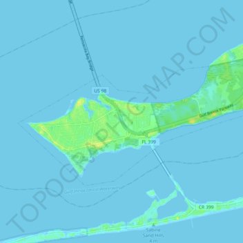
Nombre: Mapa topográfico Gulf Breeze, altitud, relieve.
Lugar: Gulf Breeze, Santa Rosa County, Florida, United States (30.34079 -87.20695 30.38181 -87.11673)
Altitud media: 1 m
Altitud mínima: -3 m
Altitud máxima: 17 m
Haz una donación
Otros mapas topográficos
Haga clic en un mapa para ver su topografía, su altitud y su relieve.
Navarre
United States > Florida > Santa Rosa County
Navarre is located at 30°24′04″N 86°51′47″W / 30.401°N 86.863°W / 30.401; -86.863Coordinates: 30°24′04″N 86°51′47″W / 30.401°N 86.863°W / 30.401; -86.863. It is located within a portion of the Florida Panhandle observing the Central Time Zone. Elevation is at an average of 10 feet (3.0 m).
Altitud media: 4 m
Navarre
United States > Florida > Santa Rosa County
As a low-elevation community near the Gulf of Mexico, Navarre is often threatened by hurricanes. Significant damage was incurred as a result of hurricanes Erin and Opal in 1995, Georges in 1998, Ivan in 2004, Dennis in 2005 and Sally in 2020. Many homes and businesses immediately along Santa Rosa Sound…
Altitud media: 4 m
Haz una donación
Haz una donación
Navarre
United States > Florida > Santa Rosa County
Navarre is located at 30°24′04″N 86°51′47″W / 30.401°N 86.863°W / 30.401; -86.863Coordinates: 30°24′04″N 86°51′47″W / 30.401°N 86.863°W / 30.401; -86.863. It is located within a portion of the Florida Panhandle observing the Central Time Zone. Elevation is at an average of 10 feet (3.0 m).
Altitud media: 4 m
Haz una donación