
Mapa topográfico Harpers Ferry
Mapa interactivo
Haga clic en el mapa para ver la altitud.
Acerca de este mapa
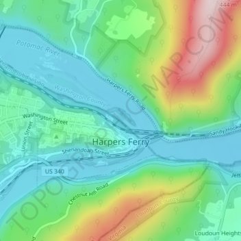
Nombre: Mapa topográfico Harpers Ferry, altitud, relieve.
Altitud media: 174 m
Altitud mínima: 71 m
Altitud máxima: 421 m
The town was "easy to seize, and hard to hold", because of its topography: surrounded on three sides by high ground – Bolivar Heights to the west, Loudoun Heights to the south, and Maryland Heights to the east – and surrounded by the Potomac and Shenandoah Rivers, anyone who controlled the heights controlled the city.
Otros mapas topográficos
Haga clic en un mapa para ver su topografía, su altitud y su relieve.
Shepherdstown
United States > West Virginia > Jefferson County
Shepherdstown, Jefferson County, West Virginia, 25443, United States
Altitud media: 126 m
Kearneysville
United States > West Virginia > Jefferson County > Kearneysville
Kearneysville, Jefferson County, West Virginia, 25430-9047, United States
Altitud media: 162 m
Harpers Ferry National Historical Park
United States > West Virginia > Jefferson County > Bolivar
Harpers Ferry National Historical Park, Bolivar, Jefferson County, West Virginia, United States
Altitud media: 161 m
Charles Town
United States > West Virginia > Jefferson County
Charles Town, Jefferson County, West Virginia, United States
Altitud media: 150 m
Halltown
United States > West Virginia > Jefferson County > Halltown
Halltown, Jefferson County, West Virginia, 25423, United States
Altitud media: 133 m