
Haz una donación
Mapa topográfico Palm Coast
Haga clic en el mapa para ver la altitud.
Haz una donación
Palm Coast
Palm Coast features a diverse and relatively flat topography, characterized by its coastal plain terrain, which gently slopes towards the Atlantic Ocean. The elevation typically ranges from about 10 to 30 feet above sea level, providing a subtle gradient that contributes to its scenic views. The area is interspersed with numerous freshwater canals, marshes, and ponds, enhancing its natural beauty and supporting a rich ecosystem. Dense clusters of subtropical vegetation, including palm trees and pines, add to the landscape, while nearby salt marshes and the sandy beaches provide unique coastal environments. Overall, Palm Coast's topography reflects a harmonious blend of inland wetlands and coastal features, making it a picturesque location for residents and visitors alike.
Haz una donación
Acerca de este mapa
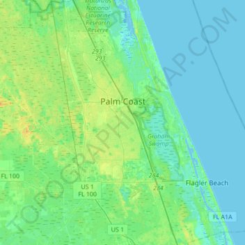
Nombre: Mapa topográfico Palm Coast, altitud, relieve.
Lugar: Palm Coast, Flagler County, Florida, United States (29.41410 -81.37164 29.65180 -81.14878)
Altitud media: 6 m
Altitud mínima: -4 m
Altitud máxima: 20 m
Haz una donación
Otros mapas topográficos
Haga clic en un mapa para ver su topografía, su altitud y su relieve.