
Mapa topográfico Uelleben
Mapa interactivo
Haga clic en el mapa para ver la altitud.
Acerca de este mapa
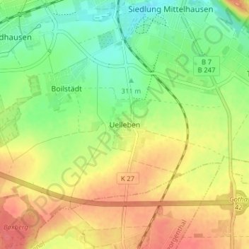
Nombre: Mapa topográfico Uelleben, altitud, relieve.
Altitud media: 329 m
Altitud mínima: 299 m
Altitud máxima: 361 m
Otros mapas topográficos
Haga clic en un mapa para ver su topografía, su altitud y su relieve.
Siebleben
Deutschland > Thüringen > Landkreis Gotha > Gotha
Siebleben, Gotha, Landkreis Gotha, Thüringen, 99867, Deutschland
Altitud media: 297 m