
Mapa topográfico 84371
Mapa interactivo
Haga clic en el mapa para ver la altitud.
Acerca de este mapa
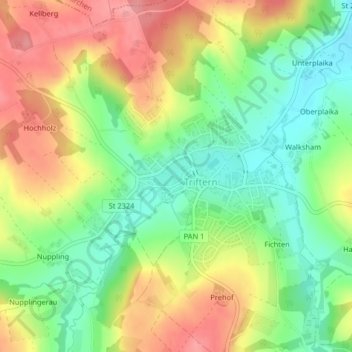
Nombre: Mapa topográfico 84371, altitud, relieve.
Lugar: 84371, Triftern, Landkreis Rottal-Inn, Bayern, Deutschland (48.39567 13.00185 48.39577 13.00195)
Altitud media: 425 m
Altitud mínima: 377 m
Altitud máxima: 479 m
Otros mapas topográficos
Haga clic en un mapa para ver su topografía, su altitud y su relieve.
Unterreitzing
Deutschland > Bayern > Landkreis Rottal-Inn > Triftern
Unterreitzing, Triftern, Landkreis Rottal-Inn, Bayern, 84371, Deutschland
Altitud media: 465 m