
Mapa topográfico Wayerton
Mapa interactivo
Haga clic en el mapa para ver la altitud.
Acerca de este mapa
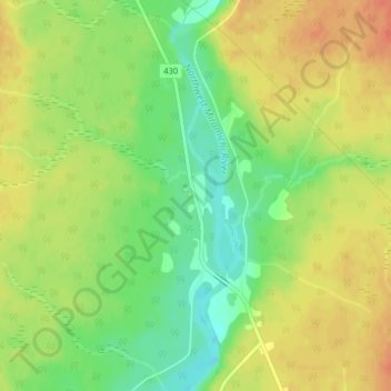
Nombre: Mapa topográfico Wayerton, altitud, relieve.
Altitud media: 46 m
Altitud mínima: 22 m
Altitud máxima: 65 m
Otros mapas topográficos
Haga clic en un mapa para ver su topografía, su altitud y su relieve.
Sevogle
Canada > New Brunswick > Northesk Parish
Sevogle, Northesk Parish, Northumberland County, New Brunswick, E9E 1R3, Canada
Altitud media: 46 m
Sunny Corner
Canada > New Brunswick > Northesk Parish
Sunny Corner, Northesk Parish, Northumberland County, New Brunswick, E9E 1J1, Canada
Altitud media: 28 m
Northwest Miramachi River
Canada > New Brunswick > Northesk Parish
Northwest Miramachi River, Northesk Parish, Northumberland County, New Brunswick, Canada
Altitud media: 214 m
Northesk
Canada > New Brunswick > Northesk Parish
Northesk, Northesk Parish, Northumberland County, New Brunswick, Canada
Altitud media: 402 m