
Haz una donación
Mapa topográfico Estang
Haga clic en el mapa para ver la altitud.
Haz una donación
Estang
Several studies have been conducted to characterize the climatic types to which the national territory is exposed. The resulting zoning varies depending on the methods used, the nature and number of parameters considered, the territorial coverage of the data, and the reference period. In 2010, the commune's climate was classified as an altered oceanic climate, according to a study by the French National Centre for Scientific Research (CNRS) based on a method combining climatic data and environmental factors (topography, land use, etc.) and data covering the period 1971-2000. In 2020, the predominant climate was classified as Cfb, according to the Köppen-Geiger classification, for the period 1988-2017, namely a temperate climate with cool summers and no dry season. Furthermore, in 2020, Météo-France published a new typology of the climates of metropolitan France, in which the commune is exposed to a modified oceanic climate and is located in the Aquitaine-Gascogne climatic region, characterized by abundant rainfall in spring, moderate rainfall in autumn, low sunshine in spring, hot summers (19.5°C), weak winds, frequent fog in autumn and winter, and frequent thunderstorms in summer (15 to 20 days). It is also located in zone H2c under the 2020 environmental regulations for new construction.
Haz una donación
Acerca de este mapa
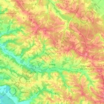
Nombre: Mapa topográfico Estang, altitud, relieve.
Altitud media: 121 m
Altitud mínima: 67 m
Altitud máxima: 163 m
Haz una donación
Otros mapas topográficos
Haga clic en un mapa para ver su topografía, su altitud y su relieve.