
Mapa topográfico Lège-Cap-Ferret
Mapa interactivo
Haga clic en el mapa para ver la altitud.
Acerca de este mapa
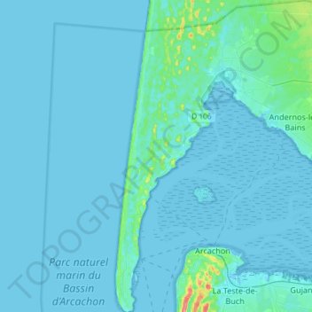
Nombre: Mapa topográfico Lège-Cap-Ferret, altitud, relieve.
Altitud media: 4 m
Altitud mínima: -2 m
Altitud máxima: 63 m
Otros mapas topográficos
Haga clic en un mapa para ver su topografía, su altitud y su relieve.
Lège-Cap-Ferret
France > Nouvelle-Aquitaine > Gironde > Lège-Cap-Ferret
Lège-Cap-Ferret, Arcachon, Gironde, Nouvelle-Aquitaine, Metropolitan France, 33740, France
Altitud media: 8 m