
Mapa topográfico Jammu and Kashmir
Mapa interactivo
Haga clic en el mapa para ver la altitud.
Acerca de este mapa
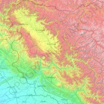
Nombre: Mapa topográfico Jammu and Kashmir, altitud, relieve.
Lugar: Jammu and Kashmir, India (32.27636 73.75003 34.78714 76.78032)
Altitud media: 2.430 m
Altitud mínima: 208 m
Altitud máxima: 7.015 m
Jammu and Kashmir is home to several valleys such as the Kashmir Valley, Tawi Valley, Chenab Valley, Poonch Valley, Sind Valley, and Lidder Valley. The Kashmir valley is 100 km (62 mi) wide and 15,520.3 km2 (5,992.4 sq mi) in area. The Himalayas divide the Kashmir valley from the Tibetan plateau while the Pir Panjal range, which encloses the valley from the west and the south, separates it from the Punjab Plain of the Indo-Gangetic Plain. Along the northeastern flank of the Valley runs the main range of the Himalayas. This valley has an average height of 1,850 metres (6,070 ft) above sea-level, but the surrounding Pir Panjal range has an average elevation of 10,000 feet (3,000 m). The Jhelum River is the major Himalayan river which flows through the Kashmir valley. The southern Jammu region is mostly mountainous, with the Shivaliks, the middle and the great Himalayas running parallel to each other in a southeast-northwest direction. A narrow southwestern strip constitutes fertile plains. The Chenab, Tawi and Ravi are important rivers flowing through the Jammu region.
Otros mapas topográficos
Haga clic en un mapa para ver su topografía, su altitud y su relieve.
Hyderabad
India > Telangana > Bahadurpura mandal
Hyderabad, Bahadurpura mandal, Hyderabad District, Telangana, India
Altitud media: 549 m
Bengaluru
India > Karnataka > Bangalore North
Bengaluru, Bangalore North, Bengaluru Urban District, Karnataka, India
Altitud media: 881 m
Dediapada Taluka
Dediapada Taluka, Narmada District, Gujarat, India
Altitud media: 248 m
Anaikatti
India > Tamil Nadu > Coimbatore North
Anaikatti, Mannarkad, Palakkad District, Kerala, 678741, India
Altitud media: 623 m
Musi River
Musi River, Hyderabad, Uppal mandal, Medchal–Malkajgiri, Telangana, 5000036, India
Altitud media: 490 m
Yachuli
India > Arunachal Pradesh > Yachuli ADC
Yachuli, Yachuli ADC, Lower Subansiri District, Arunachal Pradesh, India
Altitud media: 1.180 m
Baruipur
Baruipur, South 24 Parganas District, West Bengal, India
Altitud media: 4 m
Mangaluru
India > Karnataka > Mangaluru taluk
Mangaluru, Mangaluru taluk, Dakshina Kannada District, Karnataka, 575001, India
Altitud media: 25 m
Thiruvananthapuram
India > Kerala > Thiruvananthapuram
Thiruvananthapuram, Thiruvananthapuram District, Kerala, 695001, India
Altitud media: 33 m
Siliguri
India > West Bengal > Siliguri Subdivsion
Siliguri, Siliguri Subdivsion, Darjeeling District, West Bengal, India
Altitud media: 121 m
Rishikesh
India > Uttarakhand > Rishikesh
Rishikesh, Dehradun, Uttarakhand, 249201, India
Altitud media: 497 m
Navi Mumbai
India > Maharashtra > Thane > Navi Mumbai
Navi Mumbai, Mumbai Metropolitan Region, Thane, Maharashtra, 400706, India
Altitud media: 30 m
Delhi
India > Delhi > Kotwali Tehsil
Delhi, Kotwali Tehsil, Central Delhi, Delhi, 110006, India
Altitud media: 216 m
Dehradun
India > Uttarakhand > Dehradun
Dehradun, Dehradun District, Uttarakhand, 248001, India
Altitud media: 904 m
Pune
India > Maharashtra > Pune City > Pune
Pune, Pune City, Pune District, Maharashtra, 411001, India
Altitud media: 641 m
Thalai Nagar
India > Tamil Nadu > Veppanthattai > Thaluthalai
Thalai Nagar, Thaluthalai, Veppanthattai, Perambalur District, Tamil Nadu, 621103, India
Altitud media: 146 m
Ooty Lake
India > Tamil Nadu > Udhagamandalam > Udhagamandalam
Ooty Lake, Udhagamandalam, The Nilgiris District, Tamil Nadu, 643001, India
Altitud media: 2.235 m
Devanahalli
India > Karnataka > Devanahalli taluk
Devanahalli, Devanahalli taluk, Bengaluru Rural District, Karnataka, 562110, India
Altitud media: 900 m
Bhuntar
Bhuntar, Kullu District, Himachal Pradesh, India
Altitud media: 3.873 m
Jhimar
India > Uttarakhand > Molekhal
Jhimar, Molekhal, Almora District, Uttarakhand, India
Altitud media: 1.663 m
Dharamshala
India > Himachal Pradesh > Dharamshala
Dharamshala, Kangra District, Himachal Pradesh, 176200, India
Altitud media: 1.781 m
Surat
India > Gujarat > Katargam Taluka > Surat
Surat, Katargam Taluka, Surat, Gujarat, 395001, India
Altitud media: 11 m
Madurai
India > Tamil Nadu > Madurai
Madurai, Madurai South, Madurai district, Tamil Nadu, India
Altitud media: 138 m
Thanjavur
India > Tamil Nadu > Thanjavur
Thanjavur, Thanjavur District, Tamil Nadu, 613001, India
Altitud media: 49 m
Parasia
India > Madhya Pradesh > Parasia Tahsil > Parasia
Parasia, Parasia Tahsil, Chhindwara District, Madhya Pradesh, 480441, India
Altitud media: 786 m
Jamunia
India > Madhya Pradesh > Gairatganj Tahsil
Jamunia, Gairatganj Tahsil, Raisen District, Madhya Pradesh, India
Altitud media: 559 m
Lingoda
India > Madhya Pradesh > Agar Tahsil
Lingoda, Agar Tahsil, Agar Malwa District, Madhya Pradesh, India
Altitud media: 478 m