
Haz una donación
Mapa topográfico Fort Collins
Haga clic en el mapa para ver la altitud.
Haz una donación
Fort Collins
Fort Collins is situated at an elevation of approximately 5,003 feet (1,524 meters) above sea level, nestled at the base of the Rocky Mountains in northern Colorado. The city features a varied topography characterized by gently rolling plains that gradually rise to foothills, creating a picturesque backdrop. To the west, the rugged peaks of the Rockies loom, providing stunning vistas and numerous recreational opportunities. The Cache la Poudre River flows through the region, cutting through canyons and valleys, which enhances the area's diverse landscapes. This combination of plains, foothills, and mountainous terrain offers residents and visitors alike a rich environment for outdoor activities and breathtaking scenery.
Haz una donación
Acerca de este mapa
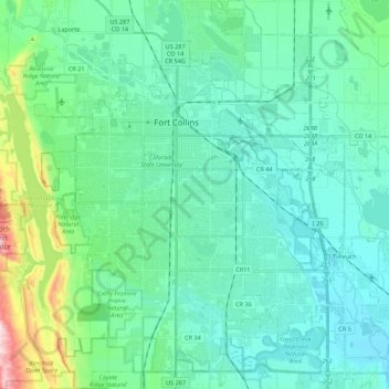
Nombre: Mapa topográfico Fort Collins, altitud, relieve.
Lugar: Fort Collins, Larimer County, Colorado, United States (40.47261 -105.15736 40.63935 -104.98200)
Altitud media: 1.548 m
Altitud mínima: 1.462 m
Altitud máxima: 1.956 m
Haz una donación
Otros mapas topográficos
Haga clic en un mapa para ver su topografía, su altitud y su relieve.
Estes Park
United States > Colorado > Larimer County
Estes Park sits at an elevation of 7,522 feet (2,293 m) on the front range of the Rocky Mountains at the eastern entrance of the Rocky Mountain National Park. Its north, south and east extremities border the Roosevelt National Forest. Lumpy Ridge lies immediately north of Estes Park.
Altitud media: 2.543 m
Estes Park
United States > Colorado > Larimer County
Estes Park sits at an elevation of 7,522 feet (2,293 m) on the front range of the Rocky Mountains at the eastern entrance of the Rocky Mountain National Park. Its location is 40°22′22″N 105°31′09″W / 40.372856°N 105.519136°W / 40.372856; -105.519136. Its north, south and east extremities…
Altitud media: 2.543 m
Haz una donación
Estes Park
United States > Colorado > Larimer County
Estes Park sits at an elevation of 7,522 feet (2,293 m) on the front range of the Rocky Mountains at the eastern entrance of the Rocky Mountain National Park. Its north, south and east extremities border the Roosevelt National Forest. Lumpy Ridge lies immediately north of Estes Park.
Altitud media: 2.420 m
Stanley Heights Subdivision
United States > Colorado > Larimer County > Estes Park
Altitud media: 2.345 m
Haz una donación
Haz una donación
Silver Lake
United States > Colorado > Larimer County > Loveland > Browns Corner
Altitud media: 1.524 m
Estes Park
United States > Colorado > Larimer County
Estes Park sits at an elevation of 7,522 feet (2,293 m) on the front range of the Rocky Mountains at the eastern entrance of the Rocky Mountain National Park. Its location is 40°22′22″N 105°31′09″W / 40.372856°N 105.519136°W / 40.372856; -105.519136. Its north, south and east extremities…
Altitud media: 2.409 m
Haz una donación
La Poudre Pass
United States > Colorado > Larimer County
La Poudre Pass (elevation 10,184 ft (3,104 m)), a high mountain pass, is located in the Rocky Mountains of northern Colorado in the United States.
Altitud media: 3.218 m
Haz una donación
Horseshoe Lake (South Dam)
United States > Colorado > Larimer County > Loveland
Altitud media: 1.515 m
Haz una donación
Estes Park
United States > Colorado > Larimer County
Estes Park sits at an elevation of 7,522 feet (2,293 m) on the front range of the Rocky Mountains at the eastern entrance of the Rocky Mountain National Park. Its north, south and east extremities border the Roosevelt National Forest. Lumpy Ridge lies immediately north of Estes Park.
Altitud media: 2.429 m
Haz una donación
Haz una donación
Stanley Heights Subdivision
United States > Colorado > Larimer County > Estes Park
Altitud media: 2.345 m
Haz una donación
Estes Park
United States > Colorado > Larimer County
Estes Park sits at an elevation of 7,658 feet (2,334 m) on the Front Range of the Rocky Mountains at the eastern entrance of the Rocky Mountain National Park. Its north, south and east extremities border the Roosevelt National Forest. Lumpy Ridge lies immediately north of Estes Park.
Altitud media: 2.543 m
Haz una donación
Haz una donación