Geolocalizar

Mapa topográfico Nieuw Bergen

Haga clic en el mapa para ver la altitud.

Acerca de este mapa

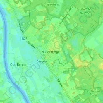
Nombre: Mapa topográfico Nieuw Bergen, altitud, relieve.

Lugar: Nieuw Bergen, Bergen, Limburg, Netherlands, 5854 BL, Netherlands (51.58497 6.03315 51.62497 6.07315)

Altitud media: 16 m

Altitud mínima: 9 m

Altitud máxima: 24 m

Otros mapas topográficos

Haga clic en un mapa para ver su topografía, su altitud y su relieve.

Sittard

Netherlands > Limburg

Altitud media: 52 m

Eygelshoven

Netherlands > Limburg

Altitud media: 118 m

Venlo

Netherlands > Limburg

Altitud media: 32 m

Maastricht

Netherlands > Limburg

Altitud media: 72 m

Heerlen

Netherlands > Limburg

Heerlen's high elevation makes it one of the highest cities above sea level in the Netherlands.

Altitud media: 131 m

Gulpen

Netherlands > Limburg

Altitud media: 141 m

Weert

Netherlands > Limburg

Altitud media: 33 m

Maastricht

Netherlands > Limburg

Altitud media: 73 m

Holtum

Netherlands > Limburg

Altitud media: 33 m

Maastricht

Netherlands > Limburg

Altitud media: 73 m

Maastricht

Netherlands > Limburg

Altitud media: 72 m

Brunssum

Netherlands > Limburg

Altitud media: 90 m

Maastricht

Netherlands > Limburg

Altitud media: 73 m

Mook

Netherlands > Limburg

Altitud media: 29 m

Maastricht

Netherlands > Limburg

Altitud media: 73 m

Maasbracht

Netherlands > Limburg

Altitud media: 25 m

Urmond

Netherlands > Limburg

Altitud media: 43 m

Well

Netherlands > Limburg

Altitud media: 18 m

Landgraaf

Netherlands > Limburg

Dutch topographic map of the municipality of Landgraaf, June 2015

Altitud media: 126 m

Kerkrade

Netherlands > Limburg

Altitud media: 140 m

Susteren

Netherlands > Limburg

Altitud media: 32 m

Broekhuizen

Netherlands > Limburg

Altitud media: 19 m

Swalmen

Netherlands > Limburg

Altitud media: 26 m

Sittard

Netherlands > Limburg

Altitud media: 52 m

Arcen

Netherlands > Limburg

Altitud media: 20 m

Maasbree

Netherlands > Limburg

Altitud media: 29 m

Baarlo

Netherlands > Limburg

Altitud media: 24 m

Posterholt

Netherlands > Limburg

Altitud media: 33 m

Stein

Netherlands > Limburg

Altitud media: 53 m

Weert

Netherlands > Limburg

Altitud media: 33 m

Maastricht-Airport

Netherlands > Limburg

Altitud media: 112 m

Roermond

Netherlands > Limburg

Altitud media: 25 m

Gennep

Netherlands > Limburg

Altitud media: 16 m

Kessel

Netherlands > Limburg

Altitud media: 27 m

Maastricht

Netherlands > Limburg

Altitud media: 73 m

Vaals

Netherlands > Limburg

Altitud media: 198 m

Meuse

Netherlands > Limburg > Baarlo

Altitud media: 22 m

Sevenum

Netherlands > Limburg

Altitud media: 29 m

Bunde

Netherlands > Limburg

Altitud media: 60 m

Cadier en Keer

Netherlands > Limburg

Altitud media: 115 m

Kerkrade

Netherlands > Limburg

Altitud media: 139 m

Valkenburg

Netherlands > Limburg

Altitud media: 123 m

Wilhelminapark

Netherlands > Limburg > Venlo

Altitud media: 23 m

Maastricht

Netherlands > Limburg

Altitud media: 73 m

Schinveld

Netherlands > Limburg

Altitud media: 72 m

Venray

Netherlands > Limburg

Altitud media: 26 m

Meuse

Netherlands > Limburg > Baarlo

Altitud media: 22 m

Roosteren

Netherlands > Limburg

Altitud media: 30 m

Panningen

Netherlands > Limburg

Altitud media: 34 m

Vaals

Netherlands > Limburg

Altitud media: 226 m

Amstenrade

Netherlands > Limburg

Altitud media: 98 m

Landgraaf

Netherlands > Limburg

Dutch topographic map of the municipality of Landgraaf, June 2015

Altitud media: 126 m

Brunssum

Netherlands > Limburg

Altitud media: 90 m

Geulle

Netherlands > Limburg

Altitud media: 75 m

Helden

Netherlands > Limburg

Altitud media: 32 m

Epen

Netherlands > Limburg

Altitud media: 169 m

Vijlen

Netherlands > Limburg

Altitud media: 190 m

Vaals

Netherlands > Limburg

Altitud media: 198 m

Vaals

Netherlands > Limburg

Altitud media: 198 m

Windraak

Netherlands > Limburg

Altitud media: 90 m

Venray

Netherlands > Limburg

Altitud media: 26 m

Voerendaal

Netherlands > Limburg

Dutch topographic map of the municipality of Voerendaal, June 2015

Altitud media: 122 m

Oirsbeek

Netherlands > Limburg

Altitud media: 96 m

Meijel

Netherlands > Limburg

Altitud media: 32 m

Koningsbosch

Netherlands > Limburg

Altitud media: 55 m

Hoensbroek

Netherlands > Limburg

Altitud media: 90 m

Nuth

Netherlands > Limburg

Altitud media: 95 m

Heerlen

Netherlands > Limburg

Heerlen's high elevation makes it one of the highest cities above sea level in the Netherlands.

Altitud media: 131 m

Ysselsteyn

Netherlands > Limburg

Altitud media: 31 m

Zuid-Limburg

Netherlands > Limburg

Altitud media: 101 m

Siebengewald

Netherlands > Limburg

Altitud media: 17 m

Brunssum

Netherlands > Limburg

Altitud media: 90 m

Eijsden-Margraten

Netherlands > Limburg

Altitud media: 115 m

Reuver

Netherlands > Limburg

Altitud media: 27 m

Venlo

Netherlands > Limburg > Venlo

Altitud media: 27 m

Geleen

Netherlands > Limburg

Altitud media: 63 m

Valkenburg

Netherlands > Limburg

Altitud media: 123 m

Born

Netherlands > Limburg

Altitud media: 34 m

Elsloo

Netherlands > Limburg > Elsloo

Altitud media: 67 m

Meuse

Netherlands > Limburg > Maastricht > Borgharen

Altitud media: 48 m

Roermond

Netherlands > Limburg

Altitud media: 25 m

Castenray

Netherlands > Limburg

Altitud media: 25 m

Limbricht

Netherlands > Limburg > Limbricht

Altitud media: 42 m

Swalmen

Netherlands > Limburg > Swalmen

Altitud media: 26 m

Eijsden

Netherlands > Limburg

Altitud media: 73 m

Simpelveld

Netherlands > Limburg

Altitud media: 173 m

Kerkrade

Netherlands > Limburg

Altitud media: 140 m