
Haz una donación
Mapa topográfico Key West
Haga clic en el mapa para ver la altitud.
Haz una donación
Key West
Key West is an island located at 24°33′55″N 81°46′33″W / 24.565176°N 81.775794°W / 24.565176; -81.775794 in the Straits of Florida. The island is about 4 miles (6 km) long and 1 mile (2 km) wide, with a total land area of 4.2 square miles (10.9 km2; 2,688.0 acres). The average elevation above sea level is about 8 feet (2.4 m) and the maximum elevation is about 18 feet (5.5 m), within a 1-acre (0-hectare) area known as Solares Hill.
Haz una donación
Acerca de este mapa
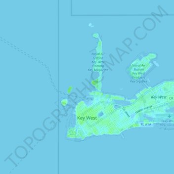
Nombre: Mapa topográfico Key West, altitud, relieve.
Lugar: Key West, Monroe County, Florida, United States (24.54367 -81.81871 24.59472 -81.72903)
Altitud media: 1 m
Altitud mínima: -2 m
Altitud máxima: 24 m
Haz una donación
Otros mapas topográficos
Haga clic en un mapa para ver su topografía, su altitud y su relieve.
Haz una donación
Florida Keys
United States > Florida > Monroe County
Tropical cyclones present special dangers and challenges to the entire Keys. Because no area of the islands is more than 20 feet (6.1 m) above sea level (and many are only a few feet elevation), and water surrounds the islands, nearly every neighborhood is subject to flooding as well as hurricane winds. In…
Altitud media: 0 m
Rock Harbor
United States > Florida > Monroe County > Key Largo
Rock Harbor is located at 25°04′37″N 80°27′36″W / 25.077°N 80.46°W / 25.077; -80.46 at an elevation of 10 feet (3 m), relatively high for the Keys.
Altitud media: 1 m
Haz una donación
Haz una donación
Haz una donación
Haz una donación
Haz una donación