
Mapa topográfico Ciudad Juárez
Mapa interactivo
Haga clic en el mapa para ver la altitud.
Acerca de este mapa
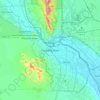
Nombre: Mapa topográfico Ciudad Juárez, altitud, relieve.
Altitud media: 1.228 m
Altitud mínima: 1.110 m
Altitud máxima: 2.072 m
Due to its location in the Chihuahuan Desert and high altitude, Ciudad Juárez has a cold desert climate (Köppen: BWk). Seasons are distinct, with hot summers, mild springs and autumns, and cold winters. Summer average high is 35 °C (95 °F) with lows of 21 °C (70 °F). Winter highs average 14 °C (57 °F) with lows of 0 °C (32 °F). Rainfall is scarce and greater in summer. Snowfalls occur occasionally (about 4 times a year), between November and March. On December 26/27, 2015, parts of the city received 40 cm (16 in) of snow within a 24-hour period beating the previous record of 28 cm (11 in) set in 1951. The record high is 49 °C (120 °F) and the record low is −23 °C (−9 °F).
Otros mapas topográficos
Haga clic en un mapa para ver su topografía, su altitud y su relieve.
Parque Cactus del Desierto
Mexico > Chihuahua > Municipio de Juárez > Ciudad Juárez
Parque Cactus del Desierto, Ciudad Juárez, Municipio de Juárez, Chihuahua, Mexico
Altitud media: 1.213 m