
Gracias por apoyar a este sitio ❤️
Haz una donación
Haz una donación
Mapa topográfico Pollock Pines
Haga clic en el mapa para ver la altitud.
Gracias por apoyar a este sitio ❤️
Haz una donación
Haz una donación
Pollock Pines
Pollock Pines is a census-designated place (CDP) in El Dorado County, California, United States. It is part of the Sacramento–Arden-Arcade–Roseville Metropolitan Statistical Area. Pollock Pines lies at an elevation of 3,980 feet (1,210 m) in the Sierra Nevada. The population was 6,871 at the 2010 census, up from 4,728 at the 2000 census.
Gracias por apoyar a este sitio ❤️
Haz una donación
Haz una donación
Acerca de este mapa
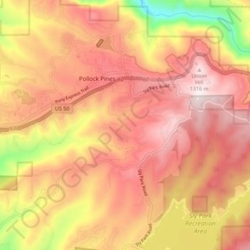
Nombre: Mapa topográfico Pollock Pines, altitud, relieve.
Altitud media: 1.118 m
Altitud mínima: 728 m
Altitud máxima: 1.344 m
Gracias por apoyar a este sitio ❤️
Haz una donación
Haz una donación