
Mapa topográfico Eheim
Mapa interactivo
Haga clic en el mapa para ver la altitud.
Acerca de este mapa
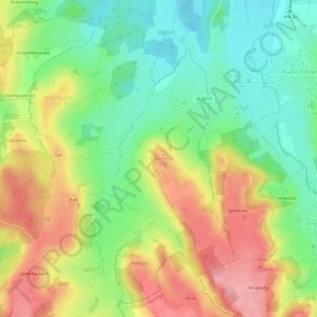
Nombre: Mapa topográfico Eheim, altitud, relieve.
Altitud media: 704 m
Altitud mínima: 646 m
Altitud máxima: 776 m
Otros mapas topográficos
Haga clic en un mapa para ver su topografía, su altitud y su relieve.
Bollenmühle
Deutschland > Bayern > Landkreis Unterallgäu > Ottobeuren > Ollarzried
Bollenmühle, Ollarzried, Ottobeuren, Landkreis Unterallgäu, Bayern, 87724, Deutschland
Altitud media: 767 m
Brüchlins
Deutschland > Bayern > Landkreis Unterallgäu > Ottobeuren
Brüchlins, Ottobeuren, Landkreis Unterallgäu, Bayern, 87749, Deutschland
Altitud media: 677 m
Guggenberg
Deutschland > Bayern > Landkreis Unterallgäu > Ottobeuren
Guggenberg, Ottobeuren, Landkreis Unterallgäu, Bayern, 87724, Deutschland
Altitud media: 696 m
Halbersberg
Deutschland > Bayern > Landkreis Unterallgäu > Ottobeuren > Langenberg
Halbersberg, Langenberg, Ottobeuren, Landkreis Unterallgäu, Bayern, 87724, Deutschland
Altitud media: 692 m