
Haz una donación
Mapa topográfico Daphne Major
Haga clic en el mapa para ver la altitud.
Haz una donación
Acerca de este mapa
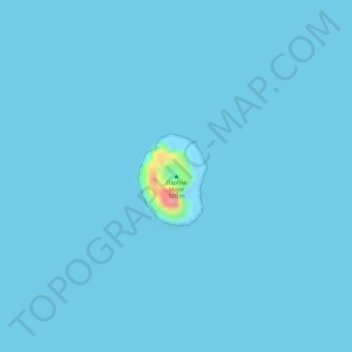
Nombre: Mapa topográfico Daphne Major, altitud, relieve.
Altitud media: 1 m
Altitud mínima: 0 m
Altitud máxima: 105 m
Haz una donación
Otros mapas topográficos
Haga clic en un mapa para ver su topografía, su altitud y su relieve.
Marchena Island
Ecuador > Galápagos > Cantón Santa Cruz
The island's name, Marchena Island (Spanish: Isla Marchena), comes from the Spanish monk, Frey Antonio de Marchena. It has an area of 130 km2 and a maximum altitude of 343 meters. The island is not set up for visitors, although the surrounding water is used by aquatic divers on organised tours.
Altitud media: 50 m
Isla Pinta
Ecuador > Galápagos > Cantón Santa Cruz
Pinta Island (Spanish: Isla Pinta), also known as Abingdon Island, after the Earl of Abingdon, is an island located in the Galápagos Islands group, Ecuador. It has an area of 60 km2 (23 sq mi) and a maximum altitude of 777 metres (2,549 ft).
Altitud media: 77 m