
Mapa topográfico Poughkeepsie
Mapa interactivo
Haga clic en el mapa para ver la altitud.
Acerca de este mapa
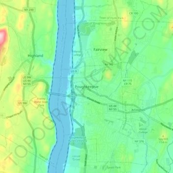
Nombre: Mapa topográfico Poughkeepsie, altitud, relieve.
Altitud media: 65 m
Altitud mínima: -8 m
Altitud máxima: 241 m
According to the United States Census Bureau, the city has an area of 5.7 square miles (14.8 km2), of which 5.1 square miles (13.3 km2) is land, and 0.23 square miles (0.6 km2) (10.05%) is water. Poughkeepsie lies approximately 75 miles (121 km) north of the center of the New York megacity. It is 73.5 miles (118.28 km) south of the New York state capital of Albany. The highest elevation of Poughkeepsie is 380 feet above sea level on College Hill. Its lowest is on the Hudson River.