
Gracias por apoyar a este sitio ❤️
Haz una donación
Haz una donación
Mapa topográfico West End
Haga clic en el mapa para ver la altitud.
Gracias por apoyar a este sitio ❤️
Haz una donación
Haz una donación
Acerca de este mapa
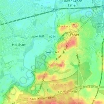
Nombre: Mapa topográfico West End, altitud, relieve.
Lugar: West End, Elmbridge, Surrey, England, KT10 8LY, United Kingdom (51.34275 -0.39929 51.38275 -0.35929)
Altitud media: 24 m
Altitud mínima: 8 m
Altitud máxima: 54 m
Gracias por apoyar a este sitio ❤️
Haz una donación
Haz una donación
Otros mapas topográficos
Haga clic en un mapa para ver su topografía, su altitud y su relieve.
Cobham
United Kingdom > England > Surrey > Elmbridge
The River Mole runs through Cobham, with a visitor area and well-surfaced path by the mill in the High Street, dividing the low-rise urban village/town centre from the remaining agricultural parts of Cobham in the west and south. This can flood small, old parts of the village centre in extreme rainfall.…
Altitud media: 28 m