
Mapa topográfico Doylestown
Mapa interactivo
Haga clic en el mapa para ver la altitud.
Acerca de este mapa
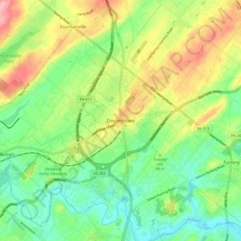
Nombre: Mapa topográfico Doylestown, altitud, relieve.
Lugar: Doylestown, Bucks County, Pennsylvania, 18901, United States (40.27004 -75.17046 40.35004 -75.09046)
Altitud media: 100 m
Altitud mínima: 51 m
Altitud máxima: 175 m
An electric telegraph station was built in 1846, and the North Pennsylvania Railroad completed a branch to Doylestown in 1856. The first gas lights were introduced in 1854. Because of the town's relatively high elevation and a lack of strong water power, substantial industrial development never occurred and Doylestown evolved to have a professional and residential character.