
Mapa topográfico Independence Charter Township
Mapa interactivo
Haga clic en el mapa para ver la altitud.
Acerca de este mapa
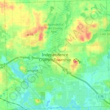
Nombre: Mapa topográfico Independence Charter Township, altitud, relieve.
Altitud media: 318 m
Altitud mínima: 288 m
Altitud máxima: 385 m
Independence Township is located along the Hillsdale-Lapeer Moraine Range. The highest hill along that range in Independence Township is Pine Knob, at 1,221 feet. It is also the highest point in Southeastern Michigan. Only three miles away is Waterford Hill, the second highest hill in Independence Township with an elevation of 1,150 feet. Atop Waterford Hill is Olympus Circle, the highest elevation of any residential street in Independence Township.
Otros mapas topográficos
Haga clic en un mapa para ver su topografía, su altitud y su relieve.
Lake Orion
United States > Michigan > Oakland County
Lake Orion, Oakland County, Michigan, 48362, United States
Altitud media: 303 m
White Lake Charter Township
United States > Michigan > Oakland County
White Lake Charter Township, Oakland County, Michigan, United States
Altitud media: 303 m
Bloomfield Hills
United States > Michigan > Oakland County
Bloomfield Hills, Oakland County, Michigan, 48304, United States
Altitud media: 261 m
Highland Charter Township
United States > Michigan > Oakland County
Highland Charter Township, Oakland County, Michigan, 48357, United States
Altitud media: 315 m
Rochester
United States > Michigan > Oakland County
Rochester, Oakland County, Michigan, United States
Altitud media: 242 m
Troy
United States > Michigan > Oakland County
Troy, Oakland County, Michigan, United States
Altitud media: 221 m
Walled Lake
United States > Michigan > Oakland County
Walled Lake, Oakland County, Michigan, United States
Altitud media: 287 m
Greens Lake
United States > Michigan > Oakland County
Greens Lake, Oakland County, Michigan, United States
Altitud media: 309 m
Oakley Park
United States > Michigan > Oakland County > Commerce Charter Township
Oakley Park, Commerce Charter Township, Oakland County, Michigan, 48390, United States
Altitud media: 282 m
Rossman Lake
United States > Michigan > Oakland County
Rossman Lake, Oakland County, Michigan, United States
Altitud media: 314 m
Southfield
United States > Michigan > Oakland County
Southfield, Oakland County, Michigan, United States
Altitud media: 210 m
Huntington Woods
United States > Michigan > Oakland County
Huntington Woods, Oakland County, Michigan, 48070, United States
Altitud media: 204 m
Keego Harbor
United States > Michigan > Oakland County
Keego Harbor, Oakland County, Michigan, United States
Altitud media: 286 m
Auburn Hills
United States > Michigan > Oakland County
Auburn Hills, Oakland County, Michigan, 48326, United States
Altitud media: 284 m
Wixom
United States > Michigan > Oakland County > Wixom
Wixom, Oakland County, Michigan, United States
Altitud media: 288 m
Novi
United States > Michigan > Oakland County
Novi, Oakland County, Michigan, United States
Altitud media: 280 m
Pleasant Ridge
United States > Michigan > Oakland County > Pleasant Ridge
Pleasant Ridge, Oakland County, Michigan, United States
Altitud media: 201 m
Royal Oak
United States > Michigan > Oakland County
Royal Oak, Oakland County, Michigan, United States
Altitud media: 203 m
South Lyon
United States > Michigan > Oakland County > South Lyon
South Lyon, Oakland County, Michigan, United States
Altitud media: 282 m
Orion Charter Township
United States > Michigan > Oakland County
Orion Charter Township, Oakland County, Michigan, United States
Altitud media: 306 m
Lakeville
United States > Michigan > Oakland County > Lakeville
Lakeville, Oakland County, Michigan, 48366, United States
Altitud media: 299 m
Pontiac
United States > Michigan > Oakland County
Pontiac, Oakland County, Michigan, United States
Altitud media: 290 m