
Haz una donación
Mapa topográfico Truckee
Haga clic en el mapa para ver la altitud.
Haz una donación
Truckee
Truckee is characterized by its dramatic topography set in the Sierra Nevada mountain range. The town sits at an elevation of approximately 5,817 feet (1,774 meters), surrounded by a stunning landscape of rugged mountains, rolling hills, and expansive forested areas. Prominent features include Donner Pass, which is a significant historical and geographical landmark, and Donner Lake, a picturesque body of water nestled among the peaks. The terrain is diverse, offering steep slopes and high-altitude trails, which are popular for hiking, biking, and skiing, particularly in winter when the region is blanketed in snow. The unique combination of elevation and natural beauty makes Truckee a prime location for outdoor enthusiasts and those seeking scenic vistas year-round.
Haz una donación
Acerca de este mapa
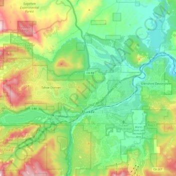
Nombre: Mapa topográfico Truckee, altitud, relieve.
Lugar: Truckee, Nevada County, California, United States (39.31616 -120.30160 39.38733 -120.07730)
Altitud media: 1.918 m
Altitud mínima: 1.661 m
Altitud máxima: 2.480 m
Haz una donación
Otros mapas topográficos
Haga clic en un mapa para ver su topografía, su altitud y su relieve.
Haz una donación
Haz una donación
Empire Mine State Historic Park
United States > California > Nevada County > Grass Valley > Boston Ravine
Altitud media: 795 m
Haz una donación
Haz una donación
Haz una donación
Haz una donación