
Mapa topográfico Pagar Alam
Mapa interactivo
Haga clic en el mapa para ver la altitud.
Acerca de este mapa
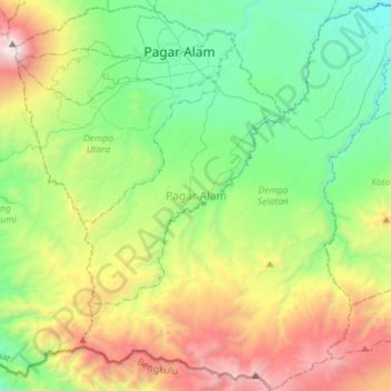
Nombre: Mapa topográfico Pagar Alam, altitud, relieve.
Lugar: Pagar Alam, South Sumatra, Indonesia (-4.26717 103.13002 -3.98478 103.41541)
Altitud media: 1.293 m
Altitud mínima: 443 m
Altitud máxima: 3.151 m
Pagaralam is located by the Bukit Barisan Mountains, at the feet of Mount Dempo. Much of the soil in the city consists of latosol and andisol with rugged and hilly topography. The soil in this city is classified as soil with high fertility (class I).