
Haz una donación
Mapa topográfico Everglades National Park
Haga clic en el mapa para ver la altitud.
Haz una donación
Everglades National Park
Everglades National Park covers 1,508,976 acres (2,357.8 sq mi; 6,106.6 km2), throughout Dade, Monroe, and Collier counties in Florida, at the southern tip of the Atlantic coastal plain. The elevation typically ranges from 0 to 8 feet (2.4 m) above sea level, but a Calusa-built shell mound on the Gulf Coast rises 20 feet (6.1 m) above sea level.
Haz una donación
Acerca de este mapa
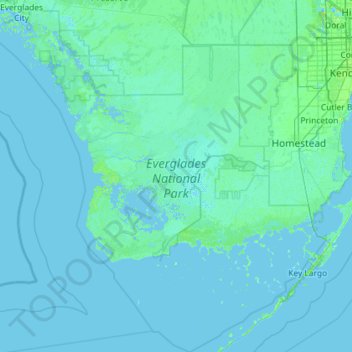
Nombre: Mapa topográfico Everglades National Park, altitud, relieve.
Lugar: Everglades National Park, Florida, 34138, United States (24.85099 -81.52053 25.89151 -80.38869)
Altitud media: 2 m
Altitud mínima: -2 m
Altitud máxima: 42 m
Haz una donación
Otros mapas topográficos
Haga clic en un mapa para ver su topografía, su altitud y su relieve.
Wesley Chapel
United States > Florida > Pasco County
According to the United States Census Bureau, the CDP has a total area of 6.1 square miles (16 km2), of which 6.1 square miles (16 km2) is land and 0.04 square miles (0.10 km2) (0.49%) is water. The elevation is about 100 feet (30 m), combined with an inland location, creates more temperature variation in the…
Altitud media: 19 m
Haz una donación
Miami
United States > Florida > Miami-Dade County
Miami and its suburbs are located on a broad plain between the Everglades to the west and Biscayne Bay to the east, which extends from Lake Okeechobee southward to Florida Bay. The elevation of the area averages at around 6 ft (1.8 m)[39] above sea level in most neighborhoods, especially near the coast. The…
Altitud media: 4 m
Haz una donación