
Gracias por apoyar a este sitio ❤️
Haz una donación
Haz una donación
Mapa topográfico Johnstown
Haga clic en el mapa para ver la altitud.
Gracias por apoyar a este sitio ❤️
Haz una donación
Haz una donación
Acerca de este mapa
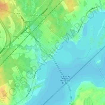
Nombre: Mapa topográfico Johnstown, altitud, relieve.
Altitud media: 83 m
Altitud mínima: 72 m
Altitud máxima: 106 m
Gracias por apoyar a este sitio ❤️
Haz una donación
Haz una donación
Otros mapas topográficos
Haga clic en un mapa para ver su topografía, su altitud y su relieve.
Edwardsburgh
Canada > Ontario > Leeds and Grenville Counties > Edwardsburgh/Cardinal
Altitud media: 92 m