
Gracias por apoyar a este sitio ❤️
Haz una donación
Haz una donación
Mapa topográfico Chalybeate Spring
Haga clic en el mapa para ver la altitud.
Gracias por apoyar a este sitio ❤️
Haz una donación
Haz una donación
Acerca de este mapa
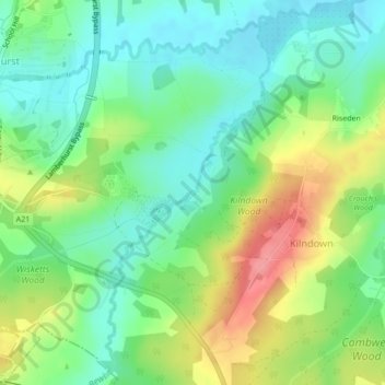
Nombre: Mapa topográfico Chalybeate Spring, altitud, relieve.
Altitud media: 65 m
Altitud mínima: 32 m
Altitud máxima: 120 m
Gracias por apoyar a este sitio ❤️
Haz una donación
Haz una donación
Otros mapas topográficos
Haga clic en un mapa para ver su topografía, su altitud y su relieve.
Bedgebury National Pinetum
United Kingdom > England > Kent > Tunbridge Wells > Kilndown
Altitud media: 91 m