
Haz una donación
Mapa topográfico Oakland Park
Haga clic en el mapa para ver la altitud.
Haz una donación
Acerca de este mapa
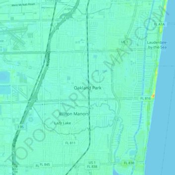
Nombre: Mapa topográfico Oakland Park, altitud, relieve.
Lugar: Oakland Park, Broward County, Florida, 33329, United States (26.13231 -80.17199 26.21231 -80.09199)
Altitud media: 6 m
Altitud mínima: -2 m
Altitud máxima: 38 m
Haz una donación
Otros mapas topográficos
Haga clic en un mapa para ver su topografía, su altitud y su relieve.
Pompano Beach
United States > Florida > Broward County
Pompano Beach features a low-elevation coastal landscape typical of southeastern Florida. With an average elevation around 20 feet above sea level, the area is flat, gradually sloping toward the Atlantic Ocean to the east. The terrain includes a blend of sandy beach areas along the coast and slightly higher,…
Altitud media: 6 m
Haz una donación
Haz una donación
Haz una donación
Haz una donación
Haz una donación
Haz una donación
Bonita Bay
United States > Florida > Broward County > Fort Lauderdale > Soroka Shores
Altitud media: 4 m
Haz una donación
Haz una donación
Haz una donación
Haz una donación
Haz una donación
Haz una donación
Haz una donación
Bonita Bay
United States > Florida > Broward County > Fort Lauderdale > Soroka Shores
Altitud media: 4 m
Haz una donación
Fort Lauderdale Beach
United States > Florida > Broward County > Fort Lauderdale > Birch Ocean Front
Altitud media: 3 m
Haz una donación