
Mapa topográfico Crawinkel
Mapa interactivo
Haga clic en el mapa para ver la altitud.
Acerca de este mapa
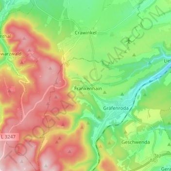
Nombre: Mapa topográfico Crawinkel, altitud, relieve.
Lugar: Crawinkel, Ohrdruf, Landkreis Gotha, Thüringen, Deutschland (50.71792 10.72425 50.79626 10.82820)
Altitud media: 536 m
Altitud mínima: 366 m
Altitud máxima: 770 m
Zu Crawinkel bemerkt Galletti in seiner topographisch-historischen Beschreibung des Gothaer Herzogtums von 1780:
Otros mapas topográficos
Haga clic en un mapa para ver su topografía, su altitud y su relieve.
Wölfis
Deutschland > Thüringen > Landkreis Gotha > Ohrdruf
Wölfis, Ohrdruf, Landkreis Gotha, Thüringen, 99885, Deutschland
Altitud media: 443 m