
Mapa topográfico Hakuba
Mapa interactivo
Haga clic en el mapa para ver la altitud.
Acerca de este mapa
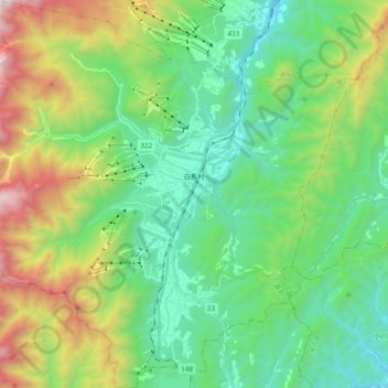
Nombre: Mapa topográfico Hakuba, altitud, relieve.
Lugar: Hakuba, Kita-Azumi County, Nagano Prefecture, Japan (36.61393 137.75002 36.76769 137.94154)
Altitud media: 1.120 m
Altitud mínima: 528 m
Altitud máxima: 2.578 m
The village has humid continental climate (Köppen Dfa), with cold, extremely snowy winters, and warm, rainy summers. With temperatures cooled by the elevation, monthly 24-hour average temperature ranges from −2.8 °C (27.0 °F) in January to 22.6 °C (72.7 °F) in July. Hakuba receives approximately 11 meters of snowfall annually, with most snowfall occurring in the months of January and February.
Otros mapas topográficos
Haga clic en un mapa para ver su topografía, su altitud y su relieve.
Mount Shirouma
Japan > Kita-Azumi County > Hakuba
Mount Shirouma, Hakuba, Kita-Azumi County, Nagano Prefecture, Japan
Altitud media: 2.461 m